Natalie Delgadillo
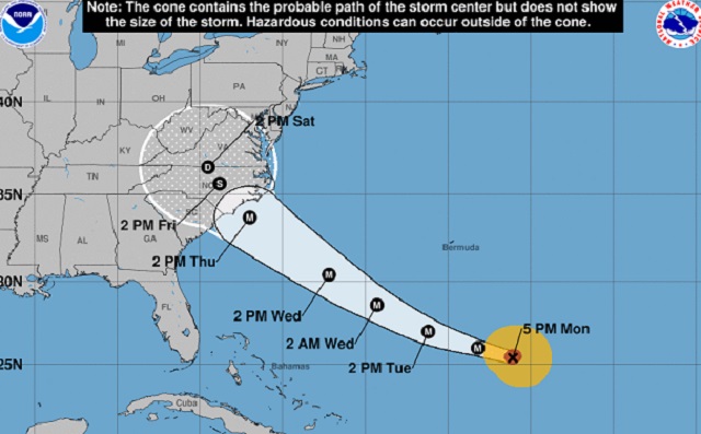 (Image courtesy of the National Weather Service)
Hurricane Florence is barreling toward the Southeast or Mid-Atlantic Coast, likely getting ready to make landfall in one of the Carolinas on Thursday night. On Monday, the storm strengthened to a Category 4 with 130 miles per hour winds.
Evacuations have already begun along the coastline in North and South Carolina, which are likeliest at this point to suffer a direct hit. What remains fairly unknown is what the storm will do when it makes landfall and what it will mean for the D.C. metro area, says National Weather Service meteorologist Kyle Pallozzi. It’s quite likely the area will get rain, but it’s not yet clear how much, Pallozzi says.
“The primary threat for most areas will be rainfall, but also coastal flooding concerns. Wind could move water into the tidal Potomac and the Chesapeake Bay,” Pallozzi says, emphasizing that those flooding concerns will mainly be along the coastline of the rivers. It’s possible that the storm will slow significantly as it moves inland, stalling out and dumping huge amounts of rain, Pallozzi says.
The wind is a secondary concern, given that storms generally weaken quickly once they make landfall, and the main circulation of Florence is expected to stay south of the D.C. area, Pallozzi says. Still, because the ground is already so saturated from large amounts of rain the last couple of months, trees are extra vulnerable to toppling, even in less intense winds, he says.
It’s relatively rare for D.C. to suffer significant effects from a hurricane. But it’s also very infrequent for hurricanes traveling on Florence’s path to end up making landfall in the Carolinas. The Chesapeake-Potomac Hurricane of 1933 is the only major storm that has tracked along Florence’s path and ended up in the Carolinas, according to AccuWeather.
It just so happens that the Chesapeake-Potomac hurricane was one of the rare few to get very, very close to D.C. “[That storm] tracked just west of D.C. and had major impacts on the area,” Pallozzi says.
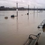
That storm flooded the Potomac River and the Chesapeake Bay with a 12-foot storm surge that put swaths of Alexandria and the District underwater.
The 2003 storm Hurricane Isabel, though it followed a slightly different track from Florence and the Chesapeake-Potomac, also side-swiped D.C. and caused tidal flooding in Navy Yard, according to the Washington Post. Over 1,500 trees fell in the city that year.
It’s important to note that there is a chance that Florence will miss this area altogether and stay in North Carolina—but it’s not the likeliest scenario by a long shot, according to Capital Weather Gang.
It’s likelier that Central Virginia will experience heavy flooding, or that tidal flooding on the rivers will inundate the whole area. (In case you’re wondering how to prepare for a storm, here you go).
Both Virginia and Maryland have now declared a state of emergency, while the National Park Service is readying itself to deploy a flood levee for the first time across 17th Avenue NW to prevent flooding downtown.