 Photo by tedeytan
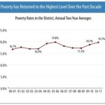
A new report from the Urban Institute says that while the D.C. area weathered the late-2000s recession “relatively well,” the region still endures a stubbornly high unemployment rate and a poverty rate of about 8 percent. The findings, released today, also include a map detailing the neighborhoods where people below the poverty line tended to dwell in 1990, 2000 and the years between 2005 and 2009. Over time, the Urban Institute reports, poverty in the D.C. area has become more diverse:
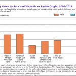
In 1990, the Washington region was home to relatively few Latinos or Asians — non-Hispanic whites and blacks accounted for 67 and 26 percent of the population respectively. So, not surprisingly, there were relatively few Latinos or Asians among the region’s poor. Today, blacks account for almost half of the poor population — at 45 percent — followed by whites (37 percent), and Latinos (18 percent). Current data are not available for Asians or other groups.
But the other key finding is that while the demographics of poverty have shifted, so too has the geography. The report’s interactive map shows that as time has passed, poor blacks remained concentrated in District neighborhoods east of the Anacostia River, while poor whites and Latinos are more broadly dispersed, largely due to the gentrification that has occurred in areas like Columbia Heights and Mount Pleasant. In recent years, the map shows, many poor white and Latino families have moved into better-off neighborhoods in the suburbs. This migration of some people below the poverty line into “non-poor” neighborhoods raises several questions for the Urban Institute:
Why do we care? Many people assume that poor people “naturally” live in poor neighborhoods, and that anti-poverty programs — like emergency food banks, job training centers, and affordable housing — should be concentrated there as well. But in fact, the vast majority of the Washington region’s poor people live in non-poor neighborhoods. They may need information and assistance finding the support services they need, especially if they live in car-dependent suburban communities or if they don’t understand English well. But poor families generally benefit from living in well-off neighborhoods where streets and parks are safe, grocery stores sell healthy, affordable food, and the public schools perform well.
High-poverty neighborhoods — like those east of the Anacostia River in D.C. — didn’t occur “naturally” nor do they reflect the “choices” of poor families about where to live. Instead, these places represent the legacy of decades of racial discrimination, legally sanctioned segregation, and public housing policies. And our map shows just how stubborn this legacy is; despite dramatic demographic and economic changes sweeping the Washington region over the past two decades, poor black families have remained highly concentrated in D.C. neighborhoods east of the Anacostia River.
Tackling poverty in the Washington region poses multiple challenges for area policymakers. It’s not just a city problem; suburban communities need to deliver support and opportunity too. It’s not just a neighborhood revitalization problem, although overcoming the legacy of segregation in the District’s poorest neighborhoods is critical. It’s not just an English-speaking problem; communities across the region have to reach out to a growing population of immigrants, many of whom speak little English. And it’s not somebody else’s problem; explore our map and you’ll likely see that poor people are among your neighbors.