Via Walk Score.
When it first launched, Walk Score could tell you how walkable certain areas in your city or town were, making an apartment search that much easier. Then the site went a step further, and began scoring transit and cycling. Now Walk Score is mapping crime.
A Urban Turf noted, the feature was rolled out today in 16 cities, including D.C.
“Crime safety is a top concern for people looking for apartments and shopping for homes. What matters most is your per capita risk of being affected by crime,” Matt Lerner, Walk Score co-founder and chief technology officer, wrote in a blog post today. “Other crime maps and statistics often make walkable neighborhoods with lots of people (e.g. Downtowns) seem unsafe because they only measure how many crimes are reported — not the per capita crime rate.”
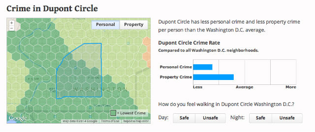
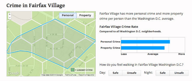
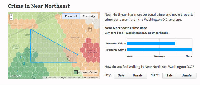
The Walk Score Crime Grade is computed using a patent-pending system that aggregates crimes near an address and weights crimes by severity and distance. We calculate a per capita crime rate for an address based on the total population (residents and workers) in the area. Crime rates are then compared against city-wide rates and converted into a letter grade. We have a separate Crime Grade for personal crime (e.g. robbery or violent crime that affects a person) and property crime (e.g. burglary or theft that affects property). This allows you to accurately compare your crime risk between addresses in a city.
There are maps for each neighborhood in D.C. that toggle between personal and property crimes.