 Rachel Sadon
 Photo by
About 1200 trips are taken on the Metropolitan Branch Trail each day. And if something happens along the way to one of those cyclists or pedestrians, they don’t necessarily have the city grid at their disposal to pinpoint their exact location.
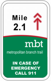 The mile markers may look like this. (via WABA)
D.C. officials say they have now come up with a solution. Mile markers will be placed at every tenth of a mile for the entire length of the trail, according to the Washington Area Bicyclist Association. Those points will be included in the Office of Uniform Communication’s database, so callers and dispatchers will have a clear sense of where they are.
In a blog post, WABA’s Garrett Hennigan explains that, right now, someone having an emergency might know that they are on the trail but have “few useful landmarks to communicate where. On the other end, the 911 dispatcher’s system requires a valid address or a selection from a limited number of hand coded points along the trail. In an emergency, even half a mile is too large a margin for error.”
And for a trail with a long history of muggings and other attacks, advocates argued that more needed to be done. The robbery of a 29-year-old cyclist earlier this month highlighted the problem.
A witness saw two men knock a woman off her bike then take $50 and a phone. But when he called 911, the dispatcher couldn’t send help because he didn’t have an exact address as to where they were on the trail.
WABA said the new signs should start going up soon.