 Rainy day (Photo by
Hurricane Joaquin is picking up steam, and since we last checked in, it’s been upgraded to a Category 4 hurricane. It’s currently raging in the Bahamas, and it’s been the strongest hurricane of the season with sustained winds of up to 130 mph. The good news is that by the time it makes its way North—perhaps sometime around Sunday or Monday—it will likely bypass D.C.
The National Hurricane Center has officially shifted the “cone of uncertainty” just east of the Mid-Atlantic Coast. It doesn’t even look like New England is at risk. Phew.
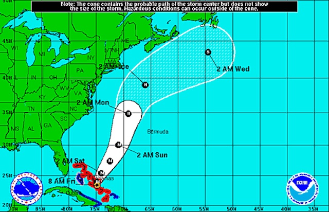 Hey, this doesn’t look so bad (National Hurricane Center)
What a difference 24 hours makes. Yesterday the National Hurricane Center was forecasting that Joaquin would be either hitting the coast or brushing up right alongside it. Its current projections make it look like there’s no chance the cyclone will hit land at all. What gives?
It turns out that American technology for predicting hurricanes is lagging. That had deadly consequence for Hurricane Sandy, which few models predicted would make a sharp turn and hit New York City. This situation is basically the reverse, where American models were predicting Joaquin would hit land, and the European model predicted Joaquin would hang out safely offshore. The New York Times explains:
Over the last few decades, faster computers, superior models and new data have allowed all weather forecasting to improve, by a lot. But the United States hasn’t quite matched that effort. It didn’t invest in computing power and models that kept up with the potential for better forecasts.
By early 2013, the European model had nearly 10 times the raw computing capacity of the Global Forecast System, or G.F.S., which is run by the National Weather Service. There were other problems, too, and the cumulative effect was obvious and irrefutable: The G.F.S. was doing worse than it rivals, and it played out in high-profile cases, like Sandy.
After Hurricane Sandy, Congress gave the National Weather Service the money for more powerful computers. In January 2015, The National Oceanic and Atmospheric Administration announced that it had increased computing capacity and begun running an upgraded model with higher resolution — a more detailed prediction.
The upgraded G.F.S. prevailed over the European model in the blizzard that largely missed New York. Many of the forecasts confidently calling for high snow totals in New York were banking on the European model, or even outright disregarded the G.F.S. But despite its early victory, the upgraded G.F.S. is still behind.
Weather experts haven’t been happy with the charts, like the one above, that the National Hurricane Center have released in the wake of preparations for Hurricane Joaquin. They’re inadequate and haven’t taken into account differing forecasts for an unpredictable storm like Joaquin.
Bryan Norcross of The Weather Channel writes on Facebook:
Trying to pin down where a hurricane is going to make landfall 4 or 5 days in the future when there’s a complex steering scenario is a fool’s game. And in reality, the cone produced by the National Hurricane Center is misleading for this storm. The cone width is fixed for the entire hurricane season based on the NHC’s average forecast accuracy over the past five years. Forecasts have been getting better, so the cone is shrinking. But this storm actually calls for a wider cone.
The two computer models that have traditionally performed best BOTH go outside of the cone – one to the right and one to the left. The cone splits the difference…
But we’ve said it before and we’ll say it again. The weather still might ruin your weekend plans.
A “predecessor surge” is going to drench the East Coast today through tomorrow. It’s going to get windy. Water levels will surge one to three feet above normal in the DC/Baltimore area. And we’re going to get doused. The National Weather Service has issued a flood watch. The rain will begin to get heavy this afternoon. Forecasters are predicted two to three inches of rain will get dumped in the area during this storm, and some of it could come so fast that flash floods are expected (especially since it’s been rainy all week and soils are saturated). The heaviest rains will continue through tomorrow morning, most likely. There’s a good chance it could continue staying breezy and damp through the weekend. The chance of it raining Sunday ticks up a little bit higher.
Even though it looks like Joaquin won’t hit us directly, there still could be direct effects around Sunday and Monday, though likely not too many. The Capital Weather Gang writes: “There’s still some question to how close it might get, but the trend has been far enough offshore not to worry too much.”
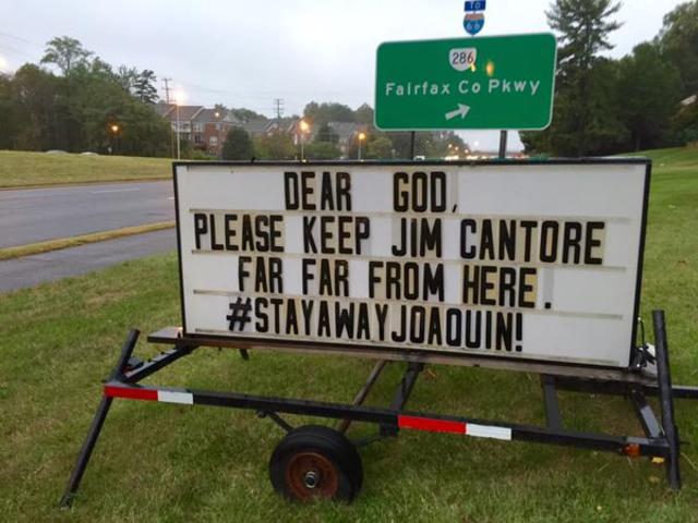
It sounds like your prayers have been answered:
Church sign in DC area. @JimCantore #joaquin pic.twitter.com/4k8zSJGbpr
— Suburb Slicker BBQ (@SuburbSlicker) October 1, 2015