Jacob Fenston
While you were standing on the roof of your sinking car, or taking an unwanted shower in a Metro train, or bailing out your basement, it probably didn’t matter to you what type of flooding you were experiencing. A flood is a flood is a flood, right?
Not really.
It turns out, we don’t know enough about the type of flooding that occurred this week. But D.C. officials are investing $5 million dollars this year to get a more detailed picture.
Because of D.C.’s location at the confluence of two tidal rivers, the city and surrounding suburbs experience three types of flooding, each affecting different neighborhoods and each requiring different strategies to mitigate. While floodgates and levees can protect from rising rivers, they are no help for what the region experienced this week.
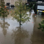
Consider Arlington’s Westover neighborhood, which saw some of the worst flooding in the D.C. area, inundating businesses along Washington Boulevard.
https://twitter.com/Paulojmendes1/status/1148276323036684288
If you check the flood risk maps created by the Federal Emergency Management Agency, you will see Westover—like many neighborhoods flooded this week—labeled as an “area of minimal flood hazard.”
That’s because the FEMA maps show floodplains and areas likely to get wet when creeks, rivers, or other waterways rise. The flood maps do not show areas at risk of flooding from drainage systems that can’t keep up with heavy rainfall. That’s what happened this week in many neighborhoods far removed from the Potomac River, the Anacostia or their many tributaries.
This week’s flooding was caused by a short, intense storm that dumped water faster than stormwater pipes could carry it away. This is called interior flooding.
D.C. is also vulnerable to riverine flooding and tidal flooding. Both of these come from our rivers, but from different directions. Tidal flooding occurs when a coastal storm surge pushes up from the Chesapeake Bay, making the Potomac and Anacostia rise out of their banks. Riverine flooding occurs when a storm upstream brings too much water down the rivers.

A flooded East Potomac Park in 1936.
Climate change is making all three types of flooding worse. Sea level is rising—already, the Potomac has risen 11 inches, and could go up another three feet. This makes tidal and riverine flooding more likely. At the same time, climate change is increasing the intensity of storms in the mid-Atlantic, meaning interior flooding is more likely, too. What was once considered a one-in-100-year storm could be a one-in-15-year storm by 2080.
Many of D.C.’s worst floods, historically, were of the riverine or tidal variety. There have been at least eight major riverine or tidal floods in the past 100 years—for example, hurricane Isabel in 2003. In recent years, there have been more instances of interior flooding—including Bloomingdale and LeDroit Park in 2012 and Federal Triangle in 2006.
Now, the District is spending $5 million to create a new, more accurate flood map that will take into account all three types of flooding as well as climate change, showing residents in much more accurate detail which areas are most ask risk.
“The modeling will tell us where to prioritize, and where the areas are more bathtub-like within the District,” says Tommy Wells, director of the District Department of Energy and Environment.
Wells says addressing those bathtub-like areas, where floodwaters can build up without draining, will be a major undertaking. It may require replacing some stormwater pipes with larger ones, and also rethinking other public areas that could hold water temporarily during an intense rainfall, keeping it from flooding homes and businesses.
“That next park that we build or redo or refurbish—maybe we need to drop that park down two or three feet so that water will be held there in the event of a major storm,” says Wells.
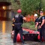
“We are seeing more intense storms like this,” says Mike Moon, chief operating officer for the Arlington County Department of Environmental Services. Moon says Arlington has just embarked on a 12-to-18-month risk assessment study, looking at flood hazards around the county
He says his department alone received 150 flood-related calls on Monday, while county-wide there were 600 emergency calls. The county is still cleaning up and assessing the damage; in county parks, six pedestrian bridges were washed out.
“We’re really appreciative of our citizens’ patience and understanding as we work through some of these issues,” says Moon.
This story originally appeared on WAMU.