Elliot C. Williams
Anyone who’s used the Google or Apple Maps app—or any transit app, really—probably knows the frustrating experience of showing up to a bus stop and seeing schedules inconsistent with when the ride actually shows up. The app said the bus was scheduled for 8:10 a.m. … so why is it pulling away from a stop two blocks down the road?
Last week, Metro shared some interesting news on Twitter that would suggest a solution to this problem: “It’s now easier than ever to plan a Metro trip thanks to real-time data in both Apple Maps & Google Maps!” The tweet comes after a November announcement that Apple Maps would lead the charge in integrating new General Transit Feed Specification-Real-Time (GTFS-RT) data, followed by Google Maps’ integration earlier in January.
The update will allow customers to see detailed transit schedules, live departure and arrival times, and the current location of buses and trains in a wider selection of apps, Metro says.
While Metro’s press release says the new data feed will make trip results more accurate on third-party apps, Brian Anderson, WMATA’s director of innovation, says the actual data being used won’t be much different from its previous system, which has showed the live location of its buses and trains since 2016. The main difference is in how the data is being presented and how accessible it is to developers behind transit apps, websites, and even formats like physical screens.
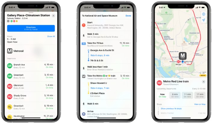
The major differences commuters will notice is the ability to see where buses and trains are on the map in real time on more apps, even though the source of the data isn’t new.
So, what explains the discrepancies in scheduling information displayed in various apps, you know, when you check one app and it shows a different schedule than the other? Anderson says that question lies with the third-party developers who use various resources to program their apps, which might not all refresh at the same rate as Metro’s data, which updates every 30 to 60 seconds on average.
The current APIs (Application Programming Interface)—Metro’s unique programming that includes service alerts, bus, and rail predictions—technically aren’t outdated. “It’s just GTFS-RT has become a standard across the industry, so by delivering the data in a format that developers want, you’re more likely to see it used in more places,” Anderson says.
The developers behind Transit—an app that updates based on crowd-sourced user information—say they’re switching to WMATA’s new data format soon. “It should be available in the app in the next couple of weeks,” says Margaux Narbey, a Transit spokesperson. “WMATA did not really say anything about differences in the accuracy of predictions, but generally speaking, GTFS-RT is more reliable and reduces the risk that real-time predictions for certain lines or trips are unavailable. GTFS-RT is also a common standard, which makes it easier for app developers, researchers, and civic technologists to use the data.”
Ian Dixon, who developed the area-specific DC Metro and Bus app, says his app still uses the previous feed, “but the benefits of switching to a standardized format will mean that a switch to GTFS is likely in the coming months.”
All that is to say that while the tracking methods aren’t changing—Metrobuses have long used on-board computers that collect GPS data and essentially “phone home” every 30 seconds to Metro’s home system—the new real-time format will be used by more apps and in a more reliable way.
Metro itself does not have a transit app of its own just yet, but Anderson says a Metro-developed app could be in the works. “We’re trying to road map what that could be in reality,” he says. As for the immediate updates, Anderson says the change should excite transit nerds and commuters alike.
“I think it just means more transit information to more people, and hopefully it allows them to make better choice to use transit,” says Anderson. “I think that there’s a little more confidence in knowing where the vehicle is and where the bus is, versus seeing a schedule and hopefully waiting there.”
This story has been corrected with a more accurate characterization of Metro’s APIs—a previous version incorrectly described them as “outdated.”