Colleen Grablick
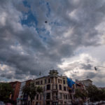
If 2020 didn’t already seem like an apocalyptic series-finale episode, a “Godzilla” dust cloud is making its way through North America — and likely reaching the D.C. area in the form of a hazy sky and more vivid sunsets.
A mass of dry air over the Saharan Desert in Northern Africa has migrated to the United States, creating a thick layer of dust over southern portions of the country. Chris Strong, a meteorologist with the Baltimore-Washington National Weather Service, forecasts predict that the D.C. area could meet the “Godzilla” dust on Sunday.
While it’s fairly common for Saharan dust to make trips across the Atlantic during the summer, the current atmospheric event is the largest and most extreme of its kind in at least 50 years, according to Vernon Morris, a researcher and director of the atmospheric sciences program at Howard University.
The plumes come from the Saharan Air Layer, which forms over Northern Africa in the spring, summer and early fall. Trade winds then carry the dust from east to west across the Atlantic, in spurts over three to five days.
The outbreaks typically peak in mid-June, according to the National Oceanic and Atmospheric Administration, occupying a 2 to 2.5-mile-thick layer in the atmosphere. Normally, the masses of dust thin out across their journey over the Atlantic, but satellite images show a peculiarly concentrated mass of dust stretching into the southeastern part of the United States.
https://twitter.com/WeatherProf/status/1275825514138210307
https://twitter.com/TylerWSFA12/status/1276151148337135619
Morris — who participates in dust research expeditions in the Atlantic — says that summer heat and wind patterns always create conditions for dust storms to carry across the Atlantic, but rising global temperatures may be allowing these current plumes to hold onto dust for longer journeys.
“I think it’s a combination of events that are happening right now,” says Morris. “We’ve had a much warmer tropical belt, and really much warmer climate. Because of those extremely high pressures, when you get a destabilization over the Sahara, the atmosphere can push out a very stable layer of air. When that air moves out over the Atlantic now, it’s so much warmer, that it can move a lot more dust a lot further.”
The threat of dust and particle-filled air comes a particularly inopportune time for the world as it faces the coronavirus – an illness that attacks the lungs. In the Caribbean ,which saw the effects of the Saharan Air Layer movement as early as last weekend, Barbados issued a warning of caution to residents with respiratory issues or allergies, and the Washington Post reported that air quality across the Caribbean reached a hazardous level.
Morris says that while the air that reaches the D.C. region would be less dense than that circulating in the South, people with respiratory concerns and sensitivity to air quality should be cautious. If the models hold true, he says what the area could see on Sunday would most likely be a milky sky in place of a vibrant and clear blue color, and purple tones in the sunset.
“[The dust masses] are going to be a lot more diffuse, it’s going to have dispersed and look a lot more hazy,” says Morris. “You’d get a deeper haze layer and something that will affect the sunrises and the sunsets a lot more.”