 Jordan Pascale
Update January 19: The U.S. Secret Service has released an updated map of street closures, which are in effect until January 21. The new closures stretch out wider than those in place Saturday, going as far north as Dupont Circle and stretch across the Anacostia.
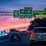
Bridges will close at 6 a.m. on Tuesday through Thursday. Mayor Muriel Bowser is urging people not to travel to the highlighted areas until after inauguration.
On Tuesday morning, the Metropolitan Police Department updated the list of bridge closures, opening the Frederick Douglass Memorial Bridge and 11th Street Bridge to local traffic. They will remain restricted to commercial vehicles. The Key Bridge will remain open, but access to Whitehurst Freeway will be closed.
All traffic entering the city on Theodore Roosevelt Bridge will be closed, and the Arlington Memorial Bridge will be closed to all traffic going either direction. Northbound traffic entering the city is restricted to all vehicles on 1-395 and 14th Street Bridge, and traffic exiting the city will flow normally.
The closures have already led to some chaotic scenes on roadways Tuesday morning. Over the weekend, some locals were worried about the impact of cutting off much of the access west of the river on those who live east of the Anacostia.

Original story: Concrete jersey barriers block many of the cross streets along K Street NW, police officers are screening people coming into downtown, and Metro has closed some of its busiest transfer stations within the security perimeter this weekend.
More fencing is going up in a farther perimeter around the Capitol and White House. The National Mall and other National Park Service areas nearby are closed.
Mayor Muriel Bowser is urging people not to come to the Downtown Central Business District area, which roughly stretches from east of the Capitol to the Lincoln Memorial and north to Massachusetts Avenue. She also told would-be visitors to stay out of Washington.
Many parking garages near the Capitol and White House were shuttered Friday. Vehicles left inside won’t be accessible until after the inauguration, officials said. Trucks delivering to businesses in the area will be sent to an off-site inspection point first.
These are just some of the unprecedented security measures taking place ahead of President-elect Joe Biden’s inauguration Wednesday. It’s set to take place just two weeks after a violent attack on the U.S. Capitol by supporters of President Donald Trump. The FBI is tracking threats of violence at the U.S. Capitol and at state capitals around the country in the coming days.
“We know this is very inconvenient for our residents and businesses,” Bowser said at a news conference this week. “I want to say thank you for your cooperation and flexibility … Clearly we are in unchartered waters.”
Many of the closures will likely have spillover effects on streets and neighborhoods around the District.
Communication around the closures has been spotty, with information coming out from a host of different agencies. Most have come out with lists of closures, not maps.
On Friday, Ward 6 Councilmember Charles Allen, who represents the Capitol Hill area, expressed frustration on Twitter: “This morning, many woke up to road closures in residential parts of #Ward6 beyond previous announcements. The Secret Service is the lead agency for Inauguration & made that call – but didn’t get the word out. I’ve talked with MPD & we’re both pushing for better comms from them.”
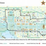
DCist / WAMU has attempted to compile a map of the known closures, though some information is incomplete and other information conflicting. Conditions are also continually changing. This map was last updated at 9:30 a.m. on Sunday. In general, do not travel downtown if you don’t need to.
The Secret Service’s closure plan, which was released Friday and has a sweeping set of closures, is subject to additions or alterations as the National Special Security Event evolves. Closures are set for Saturday, Jan. 15 until Thursday, Jan. 21. The Secret Security has set up a Red Zone and a Green Zone.
Red Zone: Vehicle traffic restricted to authorized vehicles only with proper vehicle placard. These areas have increased and hardened security.
Green Zone: Vehicle traffic restricted to residents or businesses within the restricted area and National Guard personnel will be assisting with verifying traffic entering into the Green Zone.
Purple Lines: Virginia to D.C. bridges closing Tuesday at 6 a.m. through Thursday at 6 a.m.
Brown: Bridges will close to inbound commercial vehicle traffic Tuesday from 6 a.m. through Thursday at 6 a.m.
Red X: Represent closed WMATA stations and closed streetcar service.
Yellow X: WMATA’s Pentagon station closes Wednesday only.
Red areas: Areas closed by the National Park Service
Blue areas: Designated protest zones set up for permitted protestors only. Only 100 people per area are allowed.
Yellow areas: Residents report some soft closure of streets in the Capitol Hill area, but they aren’t formally listed.
Some more of the up-to-date road closures can be found on Google Maps.
The United States Secret Service is in charge of the security plans, but Metro PD and other law enforcement agencies are assisting in creating the perimeter.
During a press conference Friday, a reporter asked Matt Miller, Special Agent in Charge of the Secret Service how downtown residents were supposed to move around.
Miller said the agency is “keenly aware” of the impact the security plan has. Specific agents have been put in charge of coordinating with businesses and buildings in 12 different zones. He says residents can get through with an ID check and should talk to property managers for further information. Management will have contact info for the agent in charge of the area.
Asked if authorities are worried about people with bad intentions spilling into neighborhoods outside the downtown zones, Miller said authorities are tracking credible threats and said MPD is in charge of securing the rest of the city. Residents shouldn’t be concerned, Miller said.
Another reporter asked Bowser if the city will go back to normal on Thursday.
“We will go back to a new normal,” Bowser said. She said the city saw white extremists storm the Capitol, who were trained, organized and ready to harm the Vice President and lawmakers. “We all have to think about a new posture in the city.”
Transit closures
Metro announced it will close 13 stations with the security perimeter in coming days through the day after Inauguration.
Starting Friday, these stations will close:
- Red Line: Farragut North, Judiciary Square, Union Station
- Yellow/Green Lines: Archives
- Blue Line: Arlington Cemetery
- Blue/Orange/Silver Lines: Farragut West, McPherson Square, Federal Center SW, Capitol South, Smithsonian, Federal Triangle

Saturday through Thursday, transfer stations Metro Center and Gallery Place will close and transfers will not be allowed there. The Pentagon station will also close on inauguration day.
Trains will pass through the closed stations without stopping.
Twenty-six Metrobus routes that go through the area will also be re-routed. Metro buses will run on a “Saturday” schedule on January 20.
“We are working closely with our regional and federal partners to keep the public safe during this National Special Security Event and to discourage travel within the secure zone,” Metro General Manager Paul Wiedefeld said in a statement. “While we are supporting law enforcement plans to enhance security, we are also keeping essential services in place for our residents who need to get to work, to medical appointments, and to grocery stores.”
VRE has canceled service through Wednesday. MARC has changed schedules. Capital Bikeshare is shuttering stations in the Capitol area.
The event’s designation as a “National Special Security Event” is starting early and is expected to have a larger perimeter than prior inaugurations.
This post has been updated with additional information on road and bridge closures.