Jacob Fenston
You’ve probably heard the old cliché that Washington was built on a swamp. It wasn’t, but much of the National Mall is built on land reclaimed from the Potomac River and its wetlands, and much of downtown, and the heart of the federal government, is built on low-lying land vulnerable to flooding. That risk is increasing due to climate change and sea level rise.
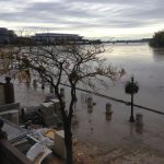
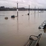
After devastating flooding in 2006, when a so-called 200-year storm dropped 7 inches of rain in one day on the District, a new removable levee wall was built on 17th St. NW, near the Washington Monument. Flooding from that storm shut down IRS Headquarters, the Commerce Department, the Justice Department, and the National Archives and several Smithsonian museums, and caused tens of millions of dollars of damage.
On Wednesday, the National Park Service conducted its yearly test of the levee closure, using a crane to install 27 aluminum panels across the roadway, held in place by nine steel posts.

“The parts are stored on flatbed trucks at the National Park Service Maintenance Facility up in Brentwood so they can be deployed at a moment’s notice,” explains NPS spokesperson Mike Litterst. This year, the panels were installed in about an hour and a half, plus travel. That’s plenty of time, Litterst says, to have the levee ready to stop a rising Potomac.
The spot on 17th St. where the levee closure is located is historically not just flood-prone, but actually part of the river. What is now the intersection of 17th and Constitution was, some 200 years ago, the confluence of Tiber Creek and the Potomac River.
The levee system dates back to the 1940s, constructed by the Civilian Conservation Corps after what was known as the Great Potomac Flood, in 1936. The system includes 12-ft. high earthen berms running along the north side of the reflecting pool, inconspicuously integrated into the landscaping.
At 17th St., engineers left a gap that could be filled in ahead of predicted flooding.
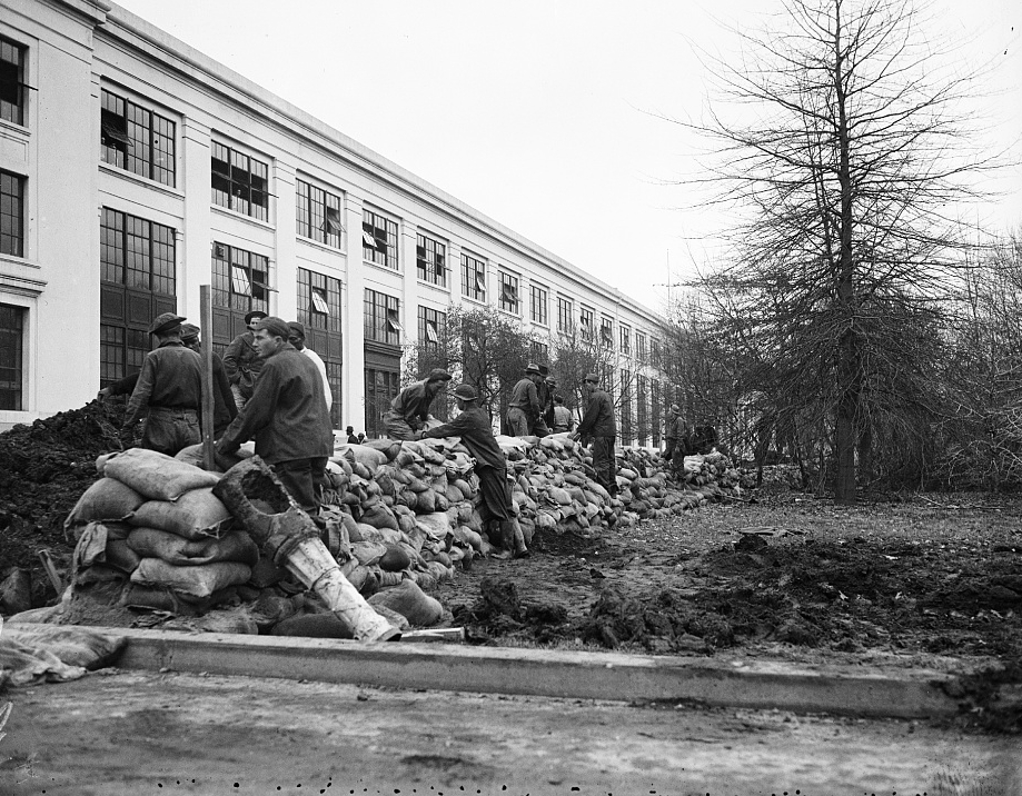
“You brought in truckloads of soil and you placed it across the street, and you put poly sheeting over top and some sandbags around it, and that was it,” says Alex Baldowski, with the U.S. Army Corps of Engineers.
The sandbag system had some drawbacks. “It’s hard to clean up. It’s also hard to bring into place. It takes a lot of manpower, it takes a lot of materials, takes a lot of time and effort,” says Baldowski.
And, most importantly, it didn’t work very well.
In 2014, the Army Corps completed the new levee closure, which includes permanent curved stone walls on both sides of 17th in addition to the temporary aluminum panels.
The levee closure protects $14 billion of property in Federal Triangle and other parts of downtown, where 40,000 people work and live. It can contain flood waters from a 100-year storm — a storm with a 1-in-100 chance of occurring in any given year.
However, global warming is changing that calculation.
As distant glaciers and ice sheets melt, raising the level of the world’s oceans, the Potomac River is rising too. The Potomac is tidal — influenced by the ocean’s level and tides — from its mouth at the Chesapeake Bay to Little Falls, at the north end of the District. The Potomac has already risen about 1 ft. from historic levels, and could rise another 3 ft. by 2080. At the same time, heavy rain events are becoming more common. What was historically considered a 100-year storm is likely to have a 1-in-25 chance of occurring each year by 2050.
When the levee system was built in the 40s, “climate change wasn’t a known idea and neither was sea level rise,” Baldowski says. “So in terms of the project being built to take those into account, it was not.”
As the climate changes, he says, “you’re more likely to put this closure structure up on a more regular basis.”
And, the levee only protects from Potomac River flooding, not from what’s known as interior flooding, where city storm drains are overwhelmed by heavy rain, causing water to back up and flood streets and buildings.
This story was updated to correct the spelling of Alex Baldowski’s name.