 Dominique Maria Bonessi
Prince George’s County is now considering an alternative map redrawing the county’s nine districts. The original plan was put forward by the county’s redistricting commission last month. Late last week, Councilmember Derrick Leon Davis (District 6) introduced changes to that plan, and on Tuesday, the council voted 6-4 to approve the alternative plan. The public will have the chance to comment on the proposed plan on Nov. 16, and the council will then vote on a final map. The deadline to adopt a final plan is Nov. 30.
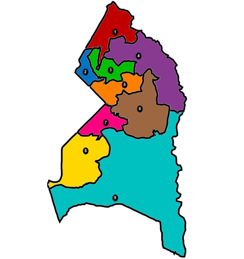
The proposed plan varies from the initial plan introduced last month by the county’s redistricting commission in shifting the boundaries for Districts 1 and 3 in the area of College Park, and it creates a majority Latino district.
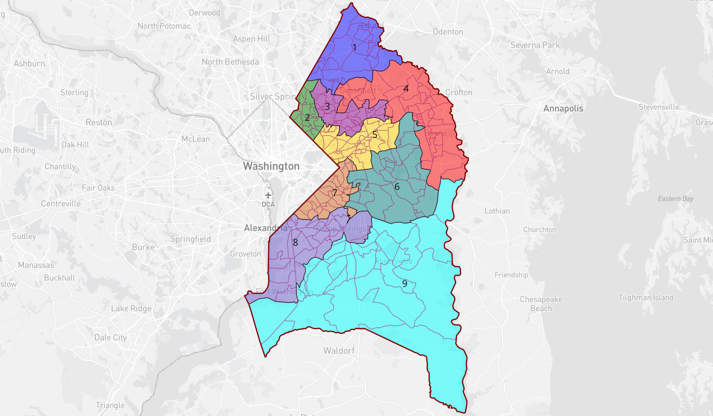
Davis initially proposed consolidating College Park into a single district; currently the area is incorporated into two districts. Davis notes that College Park is the only municipality in the county split between two districts.
“I think it’s patently unfair to all other municipalities,” Davis told his fellow council members Tuesday.
But, after receiving a letter in opposition to Davis’ plan from the City of College Park Council on Monday night, the county council voted to pass a compromise plan which keeps the area of College Park, including the University of Maryland, split between Districts 1 and 3, but with different boundary lines. Councilmembers decided to keep the University of Maryland in District 3 and have a tiny finger of District 1 cut through College Park between US-1 and the Green Line.
“I am one to compromise as well when it comes to this especially when it comes to the perspective of economic development for which is a major source of employment,” Davis said.
That compromise didn’t satisfy opponents of the plan, and council members remain divided over the new proposal.
“It looks very gerrymandered if we call it what it is,” Councilmember Danielle Glaros, who represents District 3’s area of College Park and voted against the proposed map, told DCist/WAMU. “It doesn’t really help propel the work we’ve been doing around the community…it makes everything very mucky in terms of moving forward priorities.” Glaros added that the plan disconnects and disenfranchises university neighborhoods from College Park.
The new plan also faces opposition from some residents and officials in College Park. College Park Mayor Patrick Wojahn told DCist/WAMU that the alternative plan was drawn without any input from the municipality’s residents.
“We’ve been working for decades to promote reinvestment in our community and making it an economic engine for the county,” Wojahn said. “The changes to the map muddle things they don’t really make any sense…which will make it difficult for revitalization and job creation in college park–all being done without considering the interest of college park and our residents.”
Davis rejected the suggestion that the College Park community did not have any input on his proposed map. “Those who say you have not had a say in the process, you have,” Davis told his colleagues. “This process, as [my colleagues] Mr. [Todd] Turner and Mr. [Mel] Franklin have said, has been run impeccably. And so I encourage you to continue to participate because every piece of legislation has a public hearing.”
College Park resident and activist D.W. Rowlands tweeted her opposition to the alternative plan.
“This really shows how much [Davis’] plan’s supporters are being hypocritical in claiming their plan is intended to avoid splitting municipalities when it’s actually meant as a gerrymander to prevent certain people they dislike from running for the council,” Rowlands tweeted.
Davis’s alternative map creates a majority Latino district. Currently District 2 is close to a majority at 49.5% Latino voters, but would shift to become 50.8% if the plan is adopted. The district is currently represented by Deni Taveras, the council’s only Latina councilmember. Taveras voted in favor of the alternative map.
“This is a compromise map that met the needs of [The University of Maryland] based on conversations had by core members of the council and the university,” Taveras told DCist/WAMU. “The reason I’m supporting this map is because this is the first time in history where Latinos are at the seat of the table [in the county].”
But some local residents disagree with that characterization. Rowlands told the Diamondback that shifting the Latino population from 49.5% of District 2’s population to 50.5% would not have a meaningful outcome on election results.
“This is much more symbolic than anything that actually will affect outcomes,” Rowlands said. “If your goal is to make a majority, a Latino district, you don’t make a whole bunch of other unrelated changes at the same time.”
Davis’s plan would also have implications for the 2022 primaries. For instance, former Councilmember Eric Olson was running with no challengers (so far) in District 3 (candidates have until Feb. 22 to file). Under the alternative plan, he would be running against incumbent Councilmember Tom Dernoga in District 1.
Olson told Maryland Matters that he has been door-knocking for months and believes the plan was introduced to “cut [him] out of District 3.”
“This is actually appalling, the way this was conducted,” Olson said. “It is a last-minute, radical gutting of our communities that have worked together. … It’s horrendous (and) people are outraged.”
But Davis rejected the suggestion that the map was created to hurt or help certain candidates or incumbents.
“You obviously have yet to read the county charter and understand the redistricting plan,” Davis told his colleagues while speaking to those candidates who expressed dissatisfaction with the proposed plan. “No one is entitled to a seat, you have to run for a seat in any district.”
During Tuesday’s council meeting, Councilmembers Monique Anderson-Walker (District 8) and Jolene Ivey (District 5) opposed the alternative plan and attempted to add amendments, including leaving Joint Base Andrews in Anderson-Walker’s district, but to no avail. In the end, both councilmembers voted ‘no’ on the compromise plan for Davis’ alternative map.
“This isn’t about some increase in population or density,” Ivey told councilmembers while explaining her vote. “District 1 now looks like the type of gerrymandered district that people complain about…we also know that the goal is to remove any possible [election] challengers that these members don’t like is really the goal.”
Ivey urged residents to reach out to their councilmembers about their preferred map and attend the public hearing Nov. 16.