 Jenny Gathright
The D.C. Council committee in charge of redistricting has released three maps that will influence how the panel redraws the borders of the city’s wards.
D.C. residents submitted the maps through an online tool the city launched in September. The final three proposals were chosen from over 130 submissions. The three “discussion” maps are meant to “foster productive dialogue on redistricting choices and tradeoffs,” according to the Sub-Committee on Redistricting, which consists of three at-large Councilmembers: committee chair Elissa Silverman, Anita Bonds, and Christina Henderson.
“The subcommittee’s final proposal will likely include elements from each of the three maps,” says a document explaining the process. “Each map should not be considered as a whole, but as a combination of options.”
The panel has until the Council’s first vote in December to redraw the boundaries of the city’s wards to make sure their populations are roughly equal according to 2020 census numbers, but the redistricting process will continue into 2022.
The most significant changes must be made to Wards 6, 7, and 8.
Over the past 10 years, D.C.’s population has grown the fastest in Ward 6, driven by new development in areas like NoMa, Navy Yard, and the Wharf. That means the ward will likely have to shrink in geographic size in order to abide by D.C. law, which says that the city’s eight wards need to be relatively equal in terms of population. The law permits a variance of 5% above or below the average ward population, and that means Ward 6 would have to give up at least 17,699 residents in order to comply. According to census data — which comes with some caveats, like the fact that Black and Latinx residents were likely undercounted — Wards 7 and 8 are also outside of the permitted variance. Ward 7 needs to gain at least 5,638 residents, while Ward 8 needs to gain at least 3,370 residents.
The first map is created by Ward 7 resident Keith Hasan-Towery, who chairs the Marshall Heights Civic Association and also serves as a committeeman for the D.C. Democratic Party. His map would extend Ward 8 across the Anacostia River to encompass all of Navy Yard. That would create a new ANC commission in the section of the ward that would lie west of the river. Then, according to Hasan-Towery’s map, that growth would allow Ward 7 to extend south into the Fairlawn neighborhood, which is currently in Ward 8. Historic Anacostia would remain in Ward 8. The map also extends Ward 7 further west to 15th Street NE and SE, further into Hill East and Kingman park, and far enough to create a standalone Ward 7 ANC Commission west of the Anacostia River.

The map also transfers a portion of the Shaw neighborhood north of New York Ave NW to Ward 2, and then takes some parts of the U Street neighborhood west of 14th St NW away from Ward 2 and transfers them to Ward 1. This change, according to the summary published by the subcommittee, would “allow for a more cohesive U Street neighborhood” by putting all of U St. in one ward. Finally, it gives the parts of the census tract containing the Armed Forces Retirement home to Ward 1, taking it away from Ward 5.
The second map, created by Ward 6 ANC Commissioner Corey Holman, would move most but not all of Navy Yard into Ward 8. The northeast part of Navy Yard would stay in Ward 6 because, according to the rationale in the summary, the rowhouses in that area were “designed to mimic the Capitol Hill row house neighborhoods” and the large apartment and condo buildings in the rest of Navy Yard could be considered a separate community of interest.
Holman’s map stretches Ward 7 further west of the river using the same strategy as Hasan-Towery’s map, by extending it to 15th Street NE and SE.
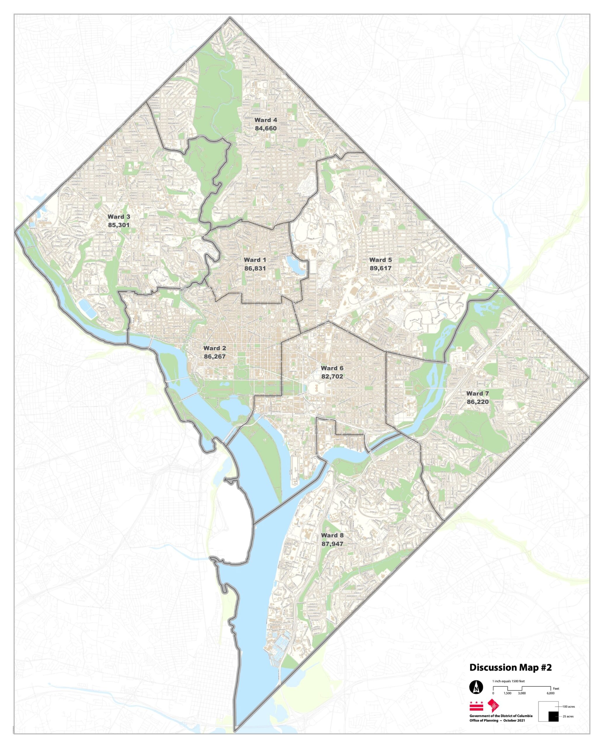
Holman’s map would also adjust the way that Shaw is divided among Wards. Ward 2 would gain the section of Shaw north of New York Ave, but it would give its territory east of 7th St. NW to Ward 6. The map would also transfer some of the U St. corridor into Ward 1 but keep the areas south of U St. between 16th St. and 18th St. NW in Ward 2. The map would also transfer East Potomac Park to Ward 6 so that residents of Southwest can have more of a say in the park’s management.
The third map, created by Ward 5 resident Geoffrey Hatchard, transfers the entire Southwest quadrant of the city to Ward 8 — a move the summary calls its “defining feature.” The map also extends the far southeast area of Ward 7 over to Suitland Parkway, meaning that Skyland, Garfield Heights and Buena Vista would move to Ward 7 but Fairlawn and Anacostia would remain in Ward 8. It also extends Ward 7 farther west of the river, but not as far as Hasan-Towery or Holman propose. It transfers portions of Shaw that lie in Ward 6 to Wards 1, 2, and 5. It is also the only one of the three maps to change Ward 4, which it does by transferring an area between Kennedy Street NE and Galloway NE from Ward 5 to Ward 4.
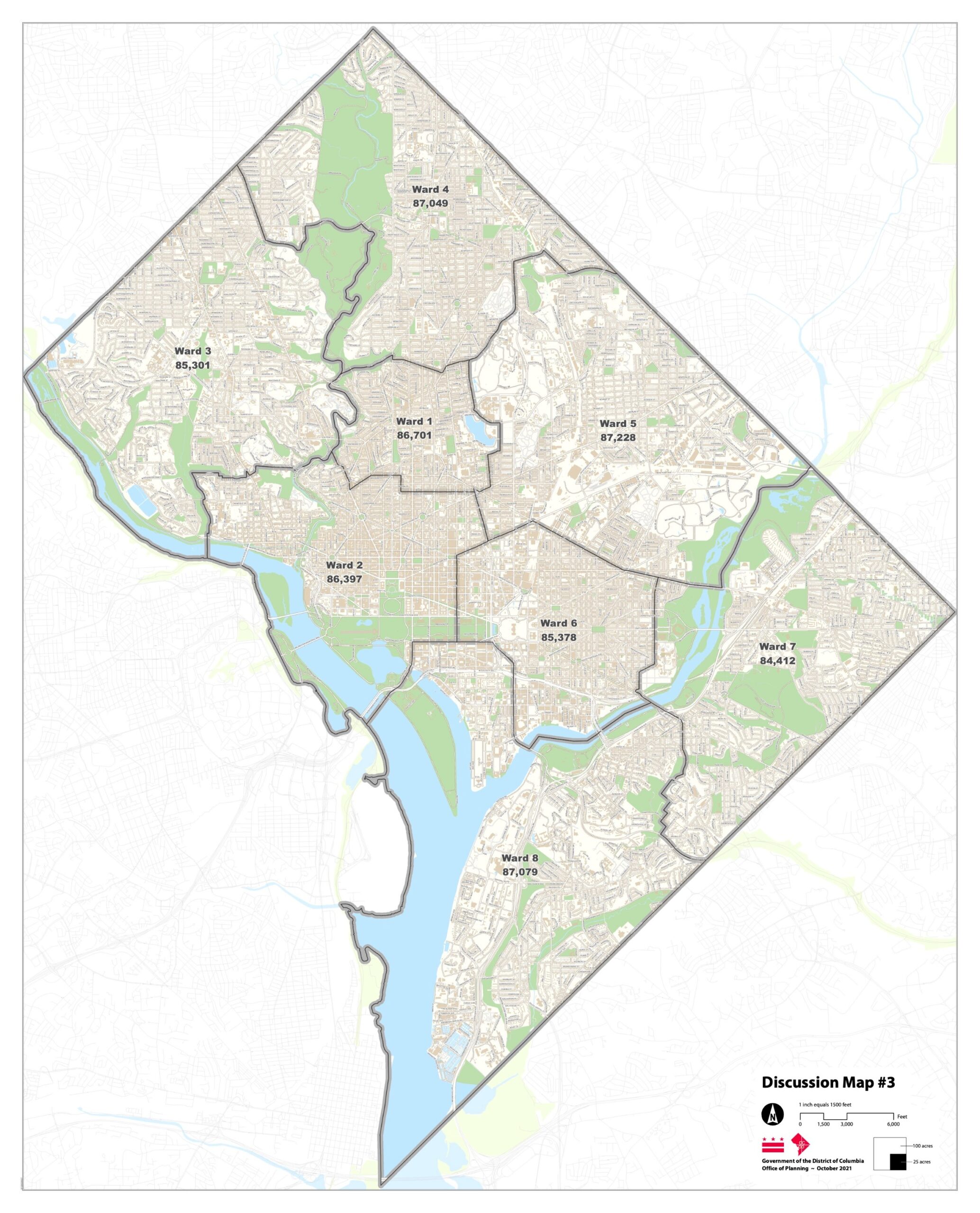
The only ward that remains untouched in all the maps is Ward 3.
The Council will hold a hearing focused on changes to Ward 6 on Wednesday, and will subsequently hold a final hearing on the citywide plan on Friday, Nov. 5. Residents who want to sign up to testify can do so by emailing redistricting@dccouncil.us. Residents can submit written testimony to that same email by Friday, Nov. 12 at 5 p.m. to redistricting@dccouncil.us or — if they’d prefer to read their testimony over the phone and have it transcribed — by calling (202) 350-1521.