Jacob Fenston
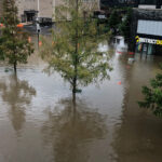
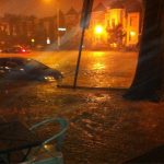
By now you’ve probably seen the photos – a major thoroughfare turned into a brown river in minutes, a doggy daycare with more than a foot of greenish water sloshing outside the glass doors, like a filthy aquarium. Twice in the past week, there’s been major flooding along Rhode Island Avenue, NE.
The reasons for this collecting water are related to geography, infrastructure, the whims of the weather gods, and, of course, climate change. But there is a fix in the works.
“That particular location there on Rhode Island Avenue is is one of the chronic spots that tends to flood whenever that area gets significant rainfall,” says John Lisle, a spokesperson for DC Water. The location in question is near the Rhode Island Avenue Metro Station, where the road passes under the railroad tracks.
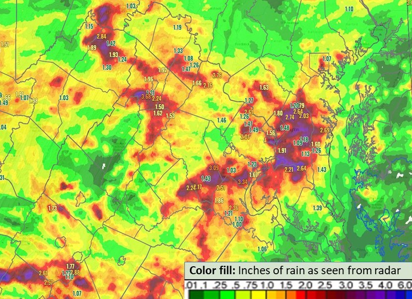
On Wednesday, rain totals varied wildly across the D.C. region, with some places in the city getting only about an inch. Bladensburg, Md. had the most rain — a total of 5 inches.
DC Water’s rain gauge near Rhode Island Avenue recorded about 2 inches of rain in a half hour, between 4:30 p.m. and 5 p.m., Lisle says.
“Part of it, it’s just unlucky,” says Nicholas Bonard, branch chief of floodplains, wetlands, and groundwater at the District Department of Energy and Environment.
“That area got a lot more rain than other areas of the city and overloaded the capacity of the stormwater system,” Bonard says.
Other areas in the region were hard-hit too: there was major flooding in Alexandria, Va. and in Riverdale Park in Prince George’s County.
In D.C., there is some relief on the way. DC Water is almost finished a major tunnel project, intended to keep sewage from overflowing into the Anacostia River. It comes with a major side benefit: it will make flooding in the area less likely.
The Northeast Boundary Tunnel, running 5 miles from Shaw to RFK Stadium, will be able to capture and store 90 million gallons of stormwater and sewage when it opens next spring, preventing that polluted mixture from overflowing into the Anacostia, and allowing it to drain from streets, reducing flooding.
“We’re adding a tremendous amount of capacity,” says Lisle. But he says, data suggest that water from this week’s storms would be enough to fill up the new tunnel, if it were in operation.
“So there could still be some flooding, but it would not be as significant as we saw yesterday,” he says.
DC Water finished digging the 23 ft. diameter tunnel in April, and is currently working on connecting it to the existing sewer system.
The spot on Rhode Island Avenue that flooded this week is particularly vulnerable because it’s at a low point, a sort of bowl where water pools. New development along the road means that when it does flood, there’s more damage and more attention to the problem.
The building where District Dogs is located, which has flooded three times this year, is built at the bottom of that bowl, on what used to be a grassy slope.
Hey @DCDPW, your storm drains aren’t working. Over 12 inches of back flow in @dcdistrictdogs yesterday. pic.twitter.com/WFmwdFizex
— Jacob Hensley (@jacobhensley) July 17, 2022
While the area is known for flooding (it also happened in 2020 and 2012), it doesn’t show up on any current flood maps. That’s because floodplain maps, created by the Federal Emergency Management Agency, show only areas prone to flooding from rivers or other bodies of water. They don’t take into account flooding caused when rain overwhelms stormwater drains – what is known as interior flooding.
New development on Rhode Island Avenue, therefore, is not subject to flood-proofing requirements, like it would be if it were located at the Wharf or Navy Yard.
“This issue of interior and stormwater flooding is something that’s only really become at the forefront in the last couple of years,” says Bonard. “Floodplain management for a long time has really just been about the water that’s coming over top of the banks of the rivers and streams and creeks.”
Climate change is causing more frequent and more intense rainfall in the D.C. area, and that is leading to more frequent interior flooding – making the old way of mapping flood risk out of date.
“Without a doubt, we can say that we’ve had more frequent and more intense rainstorms over the past decade, and that’s in line with all of the climate projections that we’ve been seeing,” says Bonard.
According to climate modeling conducted by the city, what is now considered a 100-year storm (with a 1-in-100 chance of occurring in any given year) is projected to be a 15-year storm by 2080. In other words, more than six times as likely to occur.
DOEE is currently working on an integrated flood map, that will include interior flood risk, in addition to the flood risk coming from the rivers. It’s a lot of work, and expensive, Bonard says, because it involves understanding and mapping the topography, hydrology and stormwater infrastructure of the entire city.
“If a drop of rain falls on this piece of pavement, where does it go?” Bonard says. “Which catch basin does it flow into? How large are the pipes that it flows into? What other pipes do those pipes connect to?”
In many cases, this means surveying the sewers and storm drains and even the heights of curbs. Much of this infrastructure is old, without precise records of, say, how big every pipe is.
All of this is probably little comfort to businesses who have to keep shutting down and cleaning up. But when the new flood model is complete in the next year or so, city officials will be able to model how a particular storm would affect a particular neighborhood, and then start designing new projects to mitigate that flood risk.
“It’s a multi-year process and it takes time,” says Bonard. “But we’re we’re definitely working on it.”