Satellite image from earlier today. Image credit: NOAA/NASA GOES Project I know, we’ve been a little photo heavy today. But what are you going to do when the most exciting things happening are the weather and people Monday-morning quarterbacking the egregious bad call on the weather by D.C. meteorologists? Most everyone is either trapped in their Christmas vacation locales or staying inside for one reason or another. Either way, I always look forward to…
Hurricane Earl has worked itself up to a Category 4 storm, sitting just off the coast of Puerto Rico at 7 a.m. this morning, and with winds reaching 135 mph. There were some rumblings that Earl might be the next Isabel, maintaining strength and working its way up to hit us here in D.C., but those worries seem to be unfounded.

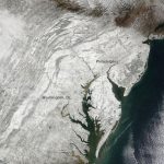
NASA image courtesy MODIS Rapid Response Team at NASA GSFC After seeing this incredible image in December, we kept our eyes peeled for photography from NASA’s Earth Observatory of last weekend’s snowstorm, and weren’t disappointed. The Terra satellite, which just celebrated ten years in space recording climate change, took this image on Sunday with the onboard Moderate Resolution Imaging Spectroradiometer (MODIS). The snow really highlights the topography around the Appalachian Mountains. NASA has been…