D.C. is full of cartographers and linguists at heart. We seem to love the intersection of maps and words, often times poking fun at ourselves or studying our inner psyches. We found this new project from Fadeout Design called “Trnsprtnation,” featuring typographical representations of six cities’ public rail systems, including our very own. The rail lines on each poster is shaped by the names of the stops along the route. The graphic isn’t as…

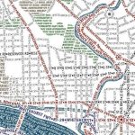
Now, we try not to do too much hawking on this here blog, but, occasionally, like with the District coffee table and the print of D.C. as a Pop Tart, we just can’t help it. That said, check out this map, created by Axis Maps, which “accurately depicts the streets and highways, parks, neighborhoods, coastlines, and physical features of Washington DC using nothing but type” culled from OpenStreetMap.