Today the whole world counts lines of longitude away from Greenwich, England. But the globally accepted prime meridian running through the Royal Greenwich Observatory is a relatively new development. At one time, most every important city had its own line: Rome, Jerusalem and St. Petersburg, among others. Of course, for a meridian line to be taken seriously by navigators and mapmakers, one had to publish an ephemeris, viz. an almanac of points on the ground and their relation to points across the Milky Way. Like with all competing standards, a shakeout eventually occurred, and by the time American democracy started teething, most everyone oriented themselves from either Greenwich or Paris.
In the New World, things were different. For one, there was the impracticality of using meridian lines based across the pond: because the Atlantic’s width was occasionally reassessed, so too would the ephemerides have to be updated. Following this standard would subject American locations to constant revision — even though they hadn’t actually gone anywhere.
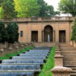
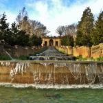
A strong secondary consideration was the symbolic value of having a prime meridian to call our own, just for the sake of national identity. Thomas Jefferson in particular would be damned if he’d let the U.S. measure from England. So in 1804 — just after the Louisiana Purchase and right as Meriwether Lewis and William Clark were heading out — he had the first American meridian drawn up. Jefferson’s meridian bisected his living quarters at the time (the White House) and ran the length of 16th Street NW from geographic pole to geographic pole. Meridian Hill (Malcolm X) Park, which lies along 16th Street between Columbia Heights and Adams Morgan, draws its (non-militant) name from this historical factoid.