 Arlington has long been a county divided. For many years, Route 50 has been the dividing line between the tony suburbs of North Arlington and the more blue-collar suburbs of South Arlington. However, Kathryn over at Kathryn on… proposes a new dividing line — one that differentiates “Nearlington” from “Farlington.”
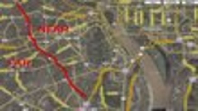
Tired of cabbies that balk at the trek across the river and DC-dwelling friends who insist that all land across the river is some vast, untamed, suburban wasteland, Kathryn takes a stab at defining just how far is far out. Glebe Road, she posits, is a natural dividing line between near and far, as it spans the length of the county, from Potomac Yard to Chain Bridge. Glebe runs roughly parallel to the Potomac for much of its course, at a distance of about 5 miles from the city, or a little more than half the breadth of Arlington County. Within the boundary described by Glebe are the areas with the greatest density in the county, many with more urban-style and transit-oriented development than most of DC proper.
The danger in this division is not only the likelihood of it fanning the flames of the city versus suburbs debate that rages endlessly, but also the distinct possibility that it will alienate the people living on the “wrong” side of the line; there are many residents of “Farlington” who are still able to get to downtown D.C. or Capitol Hill in less than 10 minutes. In and of themselves, the terms “near” and “far” are not value judgments, but in a city that values proximity to power, there is an implicit caste system that divides the close-in suburbs from the far suburbs. Perhaps it is an inevitable byproduct of the region’s popularity — as the metropolitan area continues to spread, more of the close-in suburbs will capitalize on their proximity to the city line, touting themselves as a part of the city across the river, and moving the perceived line between “near” and “far” even further.
So, readers, what is the difference between Nearlington and Farlington?