 A year ago, we geeked out over the possibility that Google Maps would soon include its Street View feature in D.C. area maps. Google has indeed collected Street View imagery for Washington, DC, but still no launch date has been announced for the feature.
In the meantime, we’ve got something a little cooler – or at least something with a comparable “gee whiz, that’s neat” factor – to tide us over. On Tuesday, Google announced that the first participants in the Cities in 3D program released their building models on Google Earth; D.C. is among the participating cities.
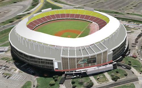
As part of the project, over 84,000 buildings in the District were rendered in 3D. Some buildings – mostly notable landmarks such as the National Cathedral, Union Station, R.F.K. Stadium and the White House – are rendered with a photorealistic façade. The effect makes the city look like something out of “The Sims.” Clicking on one of the photorealistic structures brings up an information bubble about the building.
There are some random discrepancies here and there. For instance, buildings on a cluster of four blocks north of Lincoln Park are missing. Nationals Park doesn’t appear in Google Earth at all, but buildings the ball field displaced do. And mine is the only garage on my block that wasn’t rendered, which frankly I’m not complaining about.
The data was generated by the Office of the Chief Technology Officer’s Geographic Information Systems (GIS) program. On Google Earth’s Lat-Long blog, GIS Manager Barney Krucoff listed four reasons why D.C. participated in the project. Chief among them is the D.C. government’s belief that “data created with public funds should be available to the public.” Google Earth is also a cost effective way to allow D.C. government employees to not only access and use the gathered data, but also to connect with residents.
If 3D models aren’t enough, one can download additional geospatial layers for Google Earth from the GIS Data Clearinghouse/Catalog. This can be particularly useful if you want to map out Metro station entrances; libraries; ZIP codes; and my personal favorite, no-fly zones.