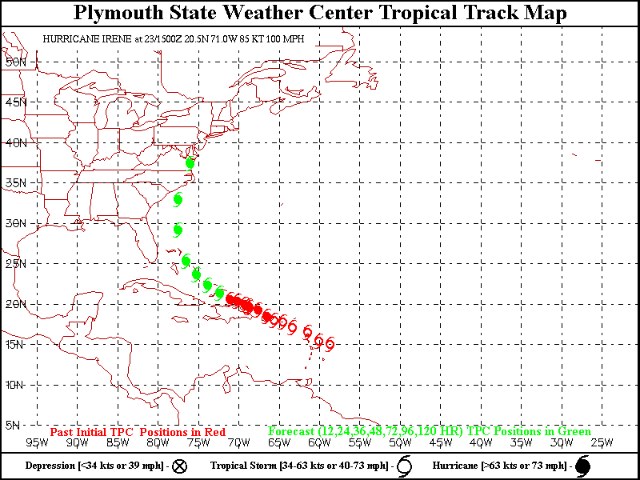

It’s been a little while — about three years, in fact — since a hurricane actually made landfall on American soil, and about eight years since one even came close to the District. But this one looks like a real doozy: Hurricane Irene is crafting a path that appears to have it slicing right up through the Chesapeake Bay this weekend.
The Capital Weather Gang breaks down the meteorology involved here:
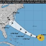
Upper level winds are likely to allow Irene to approach the East Coast, but how close?Later this week, as Irene emerges from the tropics on its poleward track east of Florida, an upper trough in the mid-latitude westerlies (outlined in red in the forecast valid early Friday morning to the right) will likely bypass Irene to the north.
It is now pretty well agreed upon by the models that this trough will not be strong enough to pull the storm out to sea. It will probably leave Irene behind in a weak steering pattern for roughly 36-48 hours that will not significantly alter her northward course and unfortunately keep it on a track that aims at eastern North Carolina. In that case, we will have to hope for the next southeastward-moving trough upstream (outlined in blue) to move into a position close enough to shove Irene eastward.
The guidance currently suggests that this may not happen in time to keep Irene completely offshore. In this scenario, where it is understood that there is 4-6 days worth of time for the meteorology to turn out differently, the Outer Banks of North Carolina would suffer a major hurricane landfall. Let’s hope this doesn’t happen.
And while it’s “premature to forecast specific details,” the threat is serious enough that organizers of this Sunday’s dedication of the Martin Luther King, Jr. Memorial are “considering alternatives” in case that torrential rains hit at the same time President Barack Obama and thousands of others are expected to be celebrating on the National Mall.
Now, before we all panic: it’s important to note that the forecasted path of a hurricane can vary wildly — even as much as 200 to 250 miles — over the span of four or five days. And, obviously, the storm will have weakened significantly by the time it would potentially reach the area.
Still, we’re thinking that you might want to carry an umbrella with you this weekend.