Expires Sunday.
Wherever you are when you wake up boozy-eyed and remorseful in the new year, take note: Your Metropolitan Police Department district or police service area may have changed.
Back in June, with denizens up in arms over the decennial redrawing of the city’s ward map, we told you that MPD was doing likewise.
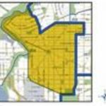
The about-to-expire police map, which was drawn up in 2004, is behind the times in many obvious areas. It doesn’t account for the growth of H Street NE or Columbia Heights, or the emergence of new neighborhoods in across the city.
MPD’s new map still contains seven districts, but all have been resized and many feature additional service areas to accomodate the changing turf. The First District, which encompasses much of downtown, Capitol Hill and Northeast up to the Anacostia River, will be more compact. The Fourth District, covering upper Northwest and Northeast, will grow.
Citywide, the new map will increase the number of police service areas from 46 to 56. That’s not to say there won’t be some cartographic oddities. Though a preliminary version of the revised map for Third District placed its headquarters at 1620 V Street NW just a block from the border with the Second District, the final map appears to leave the station a bit more centrally located. Still, the northeastern chunk of Dupont Circle is in the Third District, while the rest of that neighborhood is in the sprawling Second.
Here are links to all the new MPD district maps: