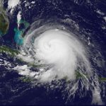
 NOAA’s GOES-East satellite captured Tropical Storm Joaquin just east of the Bahamas yesterday (Photo via NASA/NOAA GOES Project)
One thing is for sure: D.C. is in for a wet weekend. The entire Eastern Seaboard is gearing up for some heavy rains beginning on Friday through Sunday, but it could get especially gnarly if Hurricane Joaquin, which has just been officially upgraded from a tropical storm, makes landfall.
Right now Joaquin has sustained maximum winds of up to 75 mph, and it’s expected to strengthen over the next 48 hours. Hurricane warnings have been issued for the Central Bahamas. But it’s too soon to predict whether Joaquin will hit land: the current models are literally all over the map. If it does hit, it’s expected to make landfall somewhere between North Carolina and New Jersey and bring winds and flooding.
Slate outlines the worst-case scenario, though adds that it’s “unlikely” to happen:
The area of most intense concern for Hurricane Joaquin is the mid-Atlantic, from North Carolina’s Outer Banks to New Jersey. The current worst-case scenario: Many weather models have been honing in on the possibility of a Hurricane Sandy-like hard left turn into North Carolina, Virginia, or the Delmarva Peninsula, which could produce enormous impact in Washington, D.C.—this is similar to the scenario mapped out in a 2007 Washingtonian article that imagined a Category 3 hurricane entering the Chesapeake Bay and flooding the National Mall with saltwater.
The Washington Post writes that even if Joaquin doesn’t hit land, we’re in for a wet weekend: “We have a pretty good chance of seeing periods of moderate to potentially very heavy rain (several inches possible) Friday through Sunday *regardless* of Joaquin’s exact track.”