 Hurricane Joaquin (NASA)
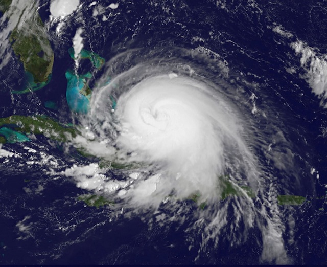
All eyes are on Hurricane Joaquin, which has gathered enough steam in the Bahamas to become a Category 3 storm over the past 24 hours. If the Hurricane takes a sharp turn west—just as Hurricane Sandy did in 2012—D.C. could be in for serious winds and flooding. But even Joaquin doesn’t make that turn and skirts just parallel to the Mid-Atlantic Coast, officials are telling D.C. to prepare for a major storm.
Mayor Muriel Bowser said today that she was briefed by the District’s Homeland Security & Emergency Management Agency (HSEMA) and senior leadership to discuss the D.C.’s efforts. Beginning tomorrow at 4:00 PM, the city will ramp up response operations at HSEMA”s Emergency Operations Center, the administration said.
Governor Terry McAuliffe already went ahead and declared a state of emergency in the Commonwealth today. The state is preparing for quite a bit of rain today and Friday—and that’s if Joaquin doesn’t hit.
“I cannot stress enough the imperative for Virginians to focus on the rainstorms that are headed our way tomorrow and Friday, well before Hurricane Joaquin could potentially impact Virginia,” McAuliffe said in a statement. “The forecast of up to 10 inches of rain in areas across Virginia could result in floods, power outages and a serious threat to life and property. As we continue to track the path of Hurricane Joaquin, I have instructed the Secretary of Public Safety and Homeland Security to make every preparation for a major event Thursday and Friday.”
The state has offered some advice for residents to prepare for the storm. Some of it is common sense: keep an eye on the news, sign up for alerts from your local government, be ready to evacuate, seek higher ground when there’s flooding, don’t drive through water and don’t walk through moving water. If you have a smart phone, you can sign up for the app Ready Virginia.
Right now the D.C. area is expected to receive 2 to 6 inches of rain without Joaquin’s arrival today and tomorrow, the Washington Post says. (That could spell trouble for events around town, including the MLS match planned for RFK Stadium Friday night.)
Joaquin is expected to pick up steam and become a Category 4 storm today with sustained winds reaching 140 mph. By the time it would reach the Mid-Atlantic, it would likely lose steam, but its winds and rains could be destructive. Right now the National Weather Service is forecasting the storm to hit land or come very close:
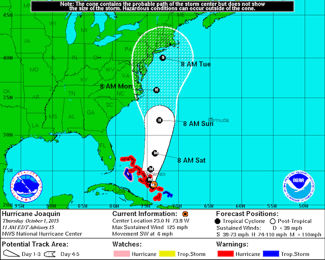 The cone shows where Joaquin could go (National Weather Service)
If Joaquin hits land, it would likely hit Sunday or Monday and it could push rainfall totals 6 to 12 inches, the Capital Gang Weather says. The Chesapeake Bay could surge, and the Potomac could flood. Other creeks, streams and low-lying areas are at risk. The weather experts say the worst case scenario could be ugly: “It is not out of the question that such a scenario could produce flooding on the scale of some of the greatest storms to ever affect the region, like Agnes in 1972.”
But right now there’s a lot of talk of the European Model, which has a wildly different prediction that says the storm will keep a healthy distance from the coast. (This model is the one that predicted Hurricane Sandy’s disastrous track long before anyone else.)
Whether or not Joaquin arrives, it’s time to be careful out there. It looks like it’s going to get hairy:
This is the only thing about Hurricane Joaquin that brings joy to my heart. Thank you whoever made this. pic.twitter.com/HeCyKCR1sz
— Reyna Desai (@reynadesai) October 1, 2015