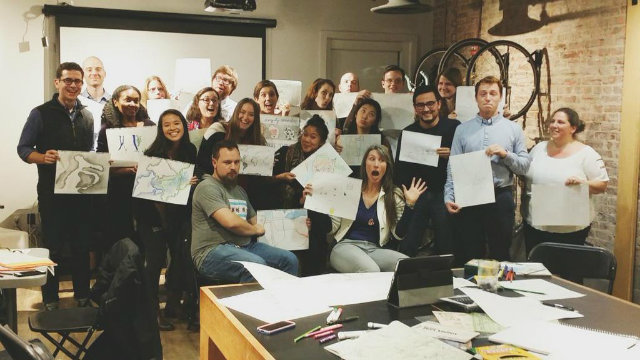
 Courtesy of Maptime DC
By DCist contributor Becky Little
Today, digital maps can help you find your phone, take you on a virtual walk around the solar system, and even tell you where your family is at all times—quite a leap from when the U.S. Census Bureau began to digitize map data in the 1970s. But it can be a daunting field for an amateur. Enter Maptime DC, a local group that wants to democratize knowledge about these increasingly valuable tools.
A group of geographers founded Maptime DC, a chapter of the international nonprofit Maptime, a year and a half ago with the hopes of creating a diverse community for those interested in learning more about mapping.
“We try to always be beginner-focused,” says Rosemary Wardley, a Maptime DC founder and senior GIS cartographer at National Geographic (where I also work). “We try to make it so all the tools are open source or freely available.”
The monthly public meetups include workshops that focus on teaching a mapping tool or concept, tutorials on how to hand-draw your own map, and “project nights” where people can work on and get help with their mapping projects. Whatever the topic, the focus is always hands-on projects that are open to people of all skill sets.
Wardley, Maptime DC organizer Courtney Claessens, and over 15 other map hackers (as the group’s Meetup page calls them) met at Rosslyn’s Esri R&D Center for one of their project nights in November. Some of the hackers had been coming to Maptime DC since it started. For others, it was their first time.
“I’m always surprised,” Wardley says, “at the cross-section of people we get.”
First-timers Mariah Braxton and Cathryn Hunt were there for help with a house-hunting app they’re developing. Once completed, Braxton and Hunt want it to calculate how far a D.C. house or apartment is from amenities like grocery stores, metro stations, laundromats, banks, and liquor stores.
They came up with the idea because finding a livable neighborhood “was a problem that we had both faced,” says Braxton. Right now, they’re focusing on amenities and housing in Petworth, but hope to expand their project to other neighborhoods.
Not everyone attends project nights to work on personal programs, though. Wade Crump, a regular at Maptime DC, attended the November meetup to work on OpenStreetMap (OSM).
“It’s been described as the Wikipedia of maps,” he says. “It is a free and open map that anyone can edit … I am particularly interested in quality assurance, completeness of the data, fixing mistakes.”
These errors—like roads that dead-end or buildings shaped like bow-ties—are flagged by other OSM users and fixed by volunteers like Crump.
Many of the people involved in Maptime DC are familiar with OSM. Last year, the Humanitarian OpenStreetMap Team asked volunteers to help them update their maps after the earthquake in Nepal, and Maptime DC responded by organizing a special session to map the affected areas. There’s also some overlap between the people who attend Maptime DC events and those who participate in MappingDC, an organization that updates local maps in OSM. In fact, Maptime DC’s founders decided to start their chapter after talking about it at an OSM conference, called State of the Map U.S.
Andrew Wiseman (full disclosure: Wiseman is a freelancer for DCist) says that at the conference, he and the other founders attended an info session about how to start your own Maptime chapter.
He recalls thinking, “Hey this is really neat, someone should organize it.” And then, in the do-it-yourself ethos of Maptime, came to his conclusion: “Why don’t we just do it?”
Maptime DC’s next meetup will be in February. You can RSVP for future events on their Meetup page.