You may live in Cuckold’s Delight or Butt’s Land, or maybe just Petworth.
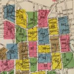
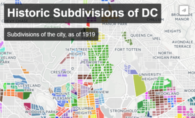
We mapped out the city’s historical subdivisions, the original divisions of land made by developers, and found that there are some names we’re familiar with and some that are… colorful. The data comes from a list of subdivisions from 1919 compiled by historian Matthew Gilmore, we then linked each subdivision to its modern squares, the way the land is divided in the city today. Hover over a colored area on the map to see its name and any other alternate names for the subdivision.
“Subdivisions are when a developer purchases a large tract of land, usually farmland, and subdivides the lot into smaller lots which will contain houses that get sold to individual property owners,” says historian and author Kent Boese. “It doesn’t matter if these are free standing houses, rowhouses, or commercial properties. They all originally belonged to a single property owner and were once recorded as a single tax lot prior to development.”
The subdivision data only exists for Washington County, D.C., the areas outside the original boundaries of the City of Washington, which were the Potomac River on the west and south and Boundary Street on the north—which today we know as Florida Avenue. The arc of that street matches the end of flat land, as north of Florida it’s steeply uphill—tougher for people on foot and horses and buggies to travel.
Boese says the land within Washington City was platted as part of the city’s original plan. Beyond the city boundaries, the land was mostly rural with large tracts of land owned by just a few landowners. In 1850, for example, the county’s population was just over 3,000 out of almost 52,000 for the District as a whole. With rapid growth after the Civil War, by 1870 it was still just 11,000 out of 131,000.
The City of Washington, Washington County and Georgetown were all separate municipalities within the District until they were merged in 1871. Alexandria County (which included what is now Arlington County and the City of Alexandria) was also a separate municipality within D.C. before its retrocession to Virginia in 1846.

Browsing the subdivision map, we see many familiar names where we’d expect them, like Anacostia, Brookland, Columbia Heights, and Woodley Park, but there are also some that don’t match our modern names at all. For example, a few subdivisions with “Mount Pleasant” in their name straddle Georgia Avenue and extend down to Florida Avenue, much too far east and south than anyone would say today. (Note that the neighborhood names displayed in gray on the map are current-day.) Many of the subdivisions include the developer’s name as well, especially to differentiate them from others with the same name.
And some neighborhood names don’t exist at all: places like Adams Morgan and Park View that were named later aren’t on the list. Adams Morgan was mostly the subdivisions of Washington Heights and Widow’s Mite, for example. Some areas presumably weren’t subdivided by 1919 either, so they don’t appear on the map. Most of those outer areas were developed around World War II or later.
Boese says the subdivisions’ names came from the developers themselves, sometimes based on some local source, such as Pleasant Plains, which was the name of the Holmead family’s estate (other subdivisions in that same area are named for the Holmead family, as is a street). Boese said names based on a well-known local place, as well as older names like Mt. Pleasant, which was created just after the Civil War, often have more staying power. He says other names might just have stuck around due to how well developers marketed them—much like NoMa today.
Some names didn’t last the years because they were mainly rural before being bought later by another developer who may have renamed it (this was the case with Park View, which was formerly Whitney Close and had few houses), others may have changed based on Citizens Associations and Civic Associations that formed around the turn of the 20th century. Those two groups served different constituencies: most Citizens Associations were white and most Civic Associations were black.
The origin of some of these subdivision names might have just been something else enitrely. Perhaps Cuckold’s Delight, the blue area in the middle of Brookland, was some inside joke by the developer? Maybe Girl’s Portion at Georgia and Aspen and Widow’s Mite around Columbia and Connecticut are references to an inheritance? And Butt’s Land at Georgia and Military, well, let’s hope that was somebody’s unfortunate last name.
Some of these subdivisions might help us better understand the current boundaries of neighborhoods. The Petworth subdivision, for example, is the biggest in the county, starting at 3rd Street NW, ending at Georgia Avenue NW (16 blocks from north to south). Any farther west and it would be a truly massive neighborhood, and the areas just to the west, sometimes (wrongly, in my opinion) referred to as Petworth, are subdivided as Fourteenth Street Heights, North Columbia Heights, and Padsworth.
Making things more complicated, Boese points out that “by 1940, the Petworth Citizens’ Association had included the area bounded by Spring Road, 13th Street, and Shepherd as part of its area—but it is also worth noting that the Columbia Heights Citizens’ Association also considered this part of their area.” (Boese mapped out many of these organizations himself.)
So maybe subdivisions aren’t the best way to define neighborhoods. At least they’re an interesting way to look into the history of any area, or laugh at it. Meet you in Cuckold’s Delight.