 Photo by Mike
Uber announced that it’s releasing travel time data that can help cities improve transportation infrastructure and reduce traffic congestion. And in the U.S., it’s starting by sharing data from D.C.
The global platform, dubbed Uber Movement, will launch in mid-February, according to The Washington Business Journal. And it’s geared toward people like urban planners.
The free service won’t show individual trips, rather segments of rides between different points. The information could help transportation officials study traffic movement and congestion over short and long periods of time, Uber said in a case study of D.C.
Particularly in the District, Uber said the data can help analyze congestion during Metro disruptions.
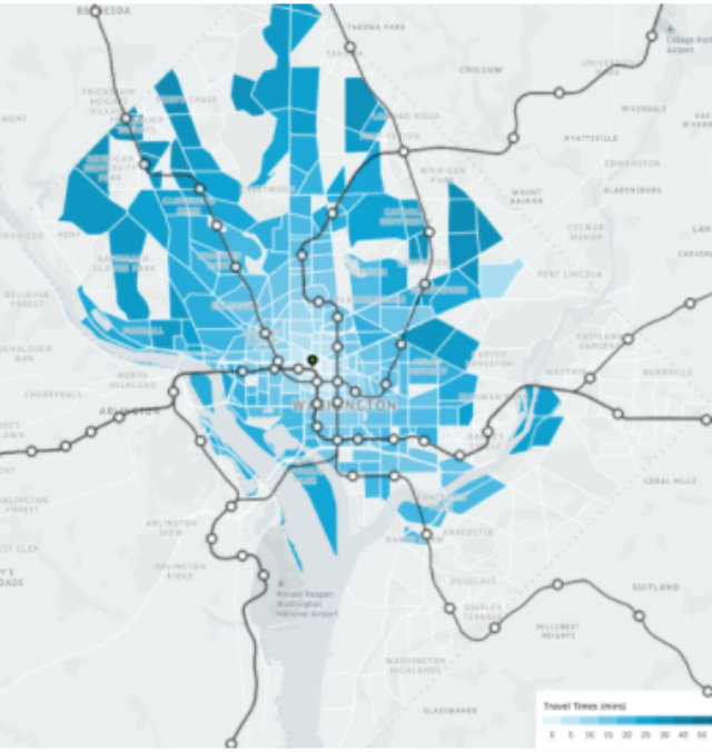
During the day-long Metrorail shutdown a Movement map shows “abnormal” travel times from downtown to other parts of D.C. ranging from 20 minutes to an excess of 33 minutes. It also details routes with the most striking times, which “roughly coincide” with several highways linking D.C. to Northern Virginia and Prince George’s County, Md.
Another example zooms in on SafeTrack’s second surge, which suspended Orange, Blue, and Silver Line service between Eastern Market and Minnesota Avenue and Benning Road stations in mid June. In comparison to the average for mid-2016, the map points to longer travel times east of downtown, largely bounded by New York Avenue NE and Pennsylvania Avenue SE. It also shows that unlike the daylong shutdown, congestion from downtown into Northern Virginia appears minimal.
Both examples “highlight the critical importance of Metrorail to the District’s and the metro region’s over transportation infrastructure,” according to the study.
While Uber expanded its discounted rides offering in the region during the start of the SafeTrack program, it isn’t trying to replace the transit system, Andrew Salzberg, Uber’s research chief, told WAMU. Instead, the company wants to “be helpful in policy arguments around how to use street space effectively.”
“We ultimately benefit from streets that move effectively, from decisions that are made based on data,” Salberg said.
 Uber released a map of rider travel times during Metrorail’s daylong shut down in March, with Metrorail lines overlaid for reference. (Photo via Uber)