 Julie Strupp
 (Photo by Tim Hoagland)
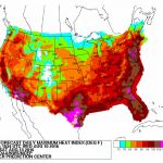
As Washington enters what is typically the hottest month of the year, computer models are predicting a sweltering week that could climax in record-setting 105-degree temperatures Thursday.
Both the Global Forecast System and European models are forecasting highs in the mid- to upper 90’s tomorrow through Thursday, when the heat wave is predicted to plateau, according to the Capital Weather Gang. However, with humidity factored in, the next three days will feel closer to 100 to 105. The National Weather Service says there’s a 42 percent chance the maximum heat index will exceed 105 degrees on Thursday, which would blow past the heat record of 100 degrees set for that day back in 1954.
It’s already been a hot summer so far. Meteorologist Alex Liggitt of ABC7 notes that D.C. has already 17 days with temperatures of 90 degrees or higher— a full week more than last year, when we had only had 10 days that hot. On average, Washington hits triple digits about once every three years, but these extreme temperatures seem to be getting more common (please see: are humans doomed?). Between the summers of 2010 and 2012, D.C. hit 100 degrees 17 times, and last summer alone we hit that number four times.
Stay cool out there, D.C.