Martin Austermuhle
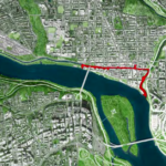
There’s a moment along the C&O about 85 miles north of D.C. where the towpath that parallels the canal suddenly emerges from the woods. As it does, the Potomac River opens up dramatically before you, and you find yourself moving along a concrete trail that seems to hover between craggy rock cliffs on one side and the placid water on the other.
This portion — known as Big Slackwater — is one of the highlights of the canal, but it may also be one you’ve never seen. And that’s not necessarily your fault. Much of the 185-mile-long Chesapeake & Ohio Canal is located in rural areas hugging the border of Maryland, Virginia, and West Virginia, where towns are few and far between. Additionally, D.C.-area denizens may rarely get beyond the C&O in Georgetown, where portions can at times seem like a forgettable ditch, or the more picturesque Great Falls.
But it’s the very scale of the canal — and its relative distance from crowds — that make it a marvel of both historic exploration and natural wonder. And given the distances involved, it’s one that can best be experienced on a bike. (Hiking is an option, of course, albeit a slower one.)
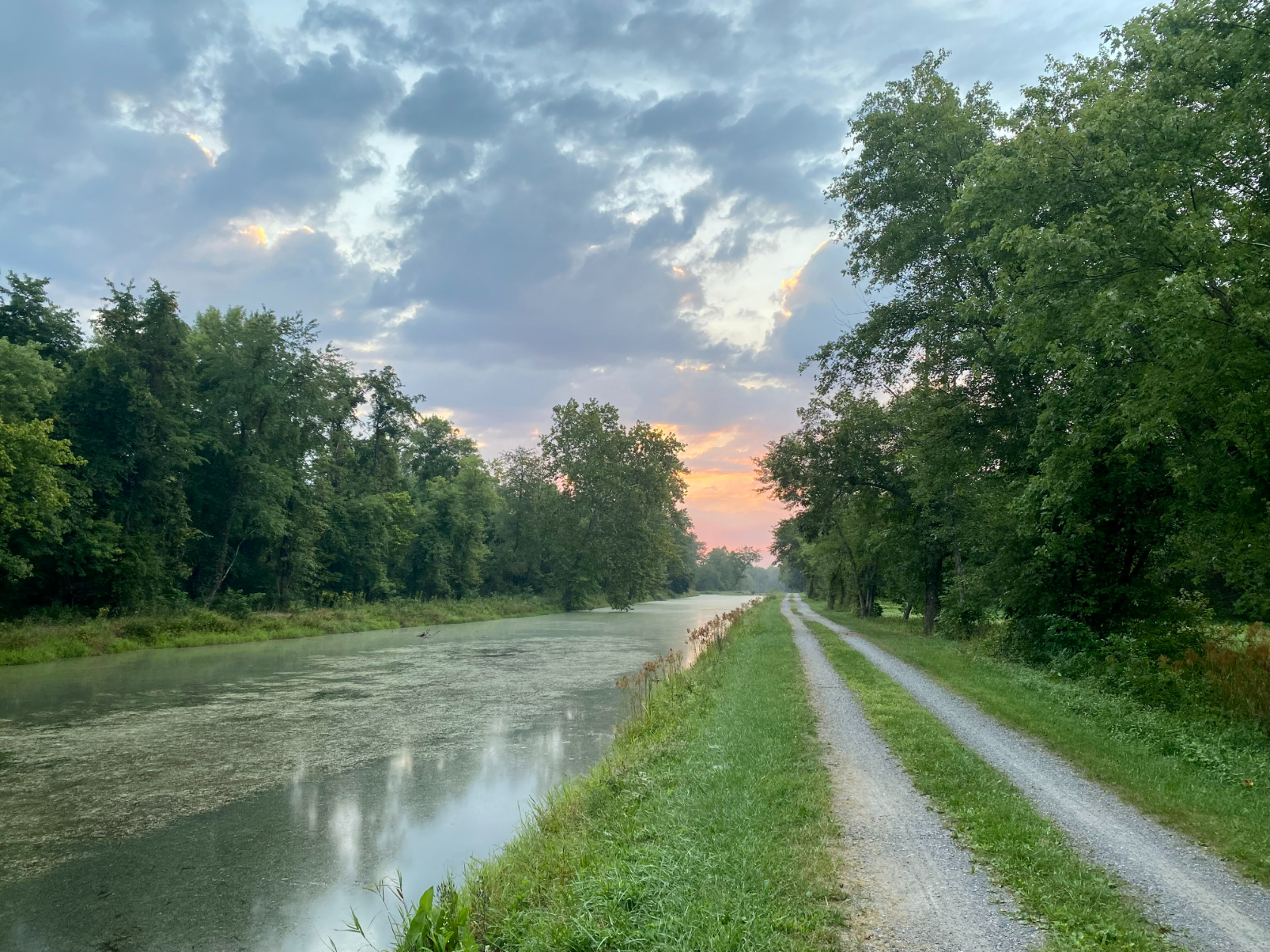
Not only is the length of the C&O largely flat — it gains roughly 600 feet in elevation heading northwards over its entire length — but segments of it have been resurfaced with crushed limestone, making for a much smoother ride than the original gravel surface you find closer to D.C. And while large stretches of the C&O are remote, the locks, small towns, and natural sights that dot its length make it perfect for rides that can stretch from a few dozen miles to the whole 185 miles.
So gear up and get going, but first check out our guide below.
How and where to ride
The C&O runs between the western panhandle town of Cumberland, Maryland and D.C., and either one is a natural starting point depending on what you’ve got planned.
If you’re aiming to ride the entire thing, you can jump on Amtrak’s daily Capitol Limited train, which stops in Cumberland on its way to Chicago, and offers dedicated bike storage. (Note: You have to reserve a bike spot ahead of time, and the spots fill up quickly.) The train also continues on to Pittsburgh; if you’re feeling adventurous enough, you can start with the Great Allegheny Passage, the 150-mile hiker-biker trail that ends in Cumberland, where the C&O picks up. (The GAP, as it’s known, is touted as one of the country’s best biking trails; consider the C&O the GAP’s slightly unloved second cousin.)
If you’re looking for a shorter jaunt, the Amtrak train also stops in Harpers Ferry, which is 60 miles up the canal from D.C. You could spend a night there before setting off to the south. Alternatively, you could ride north from Harpers Ferry up to Cumberland, and take the train back down to D.C.
On weekdays, MARC’s Brunswick line will get you up to Point of Rocks or Brunswick (roughly 40 and 55 miles north of D.C., respectively), and some get as far north as Harpers Ferry. Bikes are allowed onboard.
When to go
If you’re looking to cover the entirety of the C&O in a single day, you’re best served going during the summer months when you’ll get the longest stretch of daylight. You do risk it being hot and possibly stormy, so take that into account. If you have some more time to spare, the cooler temps and more colorful fall months may be a better option. (If you ride in late August or early September, you could well fuel on the fruit of the pawpaw trees that line parts of the canal.)
Either way, make sure you pack lights in case you have to start or finish in the dark, and be mindful of how much it has rained before you go. Much of the towpath is along the Potomac, after all, and heavy rains have been known to wash out portions of the trail. Also, the trail is gravel and largely shaded, so any significant amount of rain will take a few days to dry out.
How long will rides take? Well, it depends. The fastest known time for riding the entire 185 miles hovers around 12 hours, but that’s a punishing pace that leaves little time to appreciate the views. (More reasonable-minded people will take three to four days to cover the length of the canal.) The 60-mile jaunt from D.C. to Harpers Ferry, alternatively, is easily covered in a day.
Where to stay along the way
I’m not going to lie: if luxury accommodations are what you’re seeking to rest your weary body in between days of riding, the C&O may not be for you.
But there are plenty of other options along the way, starting with the campgrounds that are somewhat regularly located along the length of the C&O. Many of them are equipped with functioning water pumps (though you should be ready to filter or boil the water), and some also have porta-potties. And if you want a slightly more solid roof over your head, not to mention a bit of a historical experience, try one of the available lockhouses that can be rented out.
If sleeping outside after a long day in the saddle isn’t your thing, there are a few towns at somewhat regular intervals where you can find no-frills hotels. Hancock, Maryland is 60 miles along the canal from Cumberland; you can find hotels or stay in a primitive bunkhouse operated by C&O Bicycle, which helpfully can also arrange shuttle service to anywhere along the trail.
Williamsport is 25 miles beyond that, with its own motels and hotels; the West Virginia towns of Shepherdstown and Harpers Ferry are both further south and accessible via bridges from the towpath and have lodging options of their own. In Brunswick, various Airbnbs are available. At Point of Rocks, Maryland, you can even make your way into Leesburg, Virginia; a Comfort Suites there is said to run a shuttle, so it’s worth checking out that option.
Where to drink and eat along the way
Riding long distances requires fuel, and with proper planning there are plenty of options along the C&O.
Coming south from Cumberland, the towns of Little Orleans and Hancock offer the earliest options for a proper meal; the latter has a solid mix of fast-food and convenience store options, along with quirky favorite Buddylou’s Eats Drinks & Antiques. A little further south in Williamsport you can get a solid meal at the Lotus Moon Cafe, while newcomer Mama’s Lu Lu Diner is set to open this fall. With its heavy tourist draw, Harpers Ferry has plenty of options (note: you’ll need to cross a bridge across the Potomac to get there), or you could head five miles further south along the canal and stop in Brunswick, where church-turned-cafe Beans in the Belfry and Boxcar Burgers offer a range of good dishes. If you make it to White’s Ferry (35 miles north of D.C.), you’ll be more than happy to find the White’s Ferry Grill — where you can nosh down on the Pickle Sub, which is literally a sandwich that uses a massive split pickle instead of bread. (Sadly, the ferry itself remains closed.)
As always, be mindful of hours of operation; some places offer more limited hours on weekdays than they do on weekends. And carry plenty of food with you; bananas, granola bars, trail mix, and cycling-specific energy gels are usually more than enough to power you between stops.
Things to see
Part of the C&O’s appeal is how history and nature come as a package deal. It took more than two decades, starting in 1828, to dig the entirety of the canal, portions of which passed through challenging terrain and required both clever engineering and brute force from a seemingly disposable workforce. And even when it was done, luck wasn’t on the canal’s side — periodic floods did plenty of damage and the nearby B&O Railroad made for more efficient transportation of goods inland, causing the canal to cease operations in 1924. The canal officially became a national park in 1971.
Beyond the canal and the 74 locks that controlled water flow to help boats proceed upstream, one of the more famous sights along the C&O is the Paw Paw Tunnel, which tightly meanders for 3,118 feet through an imposing ridgeline towering above. Getting through the tunnel is now impossible, sadly, as a portion of the towpath is currently closed for a National Park Service-led project to shore up the surrounding area. You can walk into the tunnel from the downstream side, but will encounter a fence on the other side; getting around it requires a picturesque though challenging detour up a mountain. (There is also a motorized shuttle to help walkers and cyclists get around.) The project should be completed later this year, per the NPS.
South of Hancock, the towpath passes through Fort Frederick State Park (and alongside a portion of the canal known as Big Pool), while further south a short detour into Sharpsburg, Maryland will get you into Antietam National Battlefield. In Williamsport, there’s the new C&O Visitors Center, and no one can miss Harpers Ferry, a small town located at the confluence of the Potomac and Shenandoah rivers. And there’s of course the Monocacy Aqueduct, Great Falls, and Widewater to the south as you approach D.C.
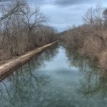
There are certainly portions of the C&O where everything looks basically the same; you have a canal (often empty) on one side, and forest on the other. But as with Big Slackwater and a bevy of other sections, the trail really shines as it directly parallels the Potomac. Sometimes you only get glimpses of the river through the trees, and other times you’re riding directly alongside a shimmering body of water full of boaters and swimmers. And when the river alone won’t do it, plenty of portions of the canal feature steep rock faces and cliffs that tower above.
Some pro tips
I’ve ridden portions of the C&O, as well as the entire stretch both over the course of two days and in a single stretch. (It took 16 hours. It was hard. I won’t do that again.) It’s not an un-challenging ride, but it’s also very accessible even to novices because, well, it’s blissfully flat. With enough training to get comfortable with long distances, anyone can tackle the C&O in its entirety.
- Need more info or guidance? There’s a fantastically helpful guide here, and the 16,500 members of the Great Allegheny Passage/C&O Canal Enthusiasts Facebook group are about as good a real-time resource as you can get. (Today’s intel: a tree down at mile marker 92.) Get your official C&O map here.
- In terms of bikes, most anything with tires wider than 35 mm should do just fine; no mountain bike needed. As always, be prepared to deal with any flats by bringing spare tubes and a pump.
- Want to nerd out on history before you go or as you ride? Check “The C&O Canal Companion: A Journey Through Potomac History.” There’s also “Secrets of the C&O Canal: Little-Known Stories & Hidden History Along the Potomac River.”
- If you think you’ll need a break from riding long distances on gravel, the Western Maryland Rail Trail is a paved 28-mile option that directly parallels the C&O from just north of Hancock to just north of Williamsport. Pavement never seemed so glorious.
- The National Park Service helpfully placed mile markers along the entirety of the canal’s 185 miles, so you’ll always know how far you have yet to ride. Whether this is helpful or hellish is left to the rider; counting down 185 miles over the course of a single day is enough to drive anyone mildly crazy.
- Want to mix it up? Ride the C&O from D.C. to Point of Rocks, cross the bridge into Virginia and make your way to Leesburg, where you can pick up the paved W&OD Trail back into the city. It’s about 100 miles all told.
- Really want to mix it up? Do the entire C&O/GAP combo, stretching 335 miles from D.C. to Pittsburgh. It’s an epic ride, and one best done heading south; there’s a slight decline as you make your way towards D.C., and any advantage you can get is one you should take.