Martin Austermuhle

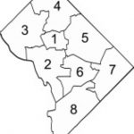
Many wars have been fought over contested borders and boundaries, and two small technical errors written into the District’s recent redistricting could well have pitted four wards against each other in epic showdowns over territory and treasure.
Okay, maybe that’s a little bit of an overstatement. But it’s mostly true.
The Post’s Mike DeBonis has got all the details, but here’s the basics — the legislation that formally redistricted the city’s eight wards this summer mistakenly overlapped two parcels of land, one between Wards 5 and 6 and the other between Wards 7 and 8. Had the mistake not been noticed earlier this morning by Trinidad resident and local curmudgeon Geoff Hatchard, it could well have remained an unlit fuse just waiting for a spark before leading to a costly internal battle between councilmembers and their respective residents. (Okay, again, an overstatement, but hey, it’s fun to imagine.)
According to Councilmember Michael Brown (I-At-Large), who along with colleagues Phil Mendelson (D-At-Large) and Jack Evans (D-Ward 2) oversaw the redistricting process, the overlaps will be corrected at a November 1 Council hearing. Additionally, his aides informed us, Brown will be distributing maps of the redistricted wards and other boundary changes so that councilmembers and residents don’t only have to rely on the language written into the law.
The redistricting process is still ongoing, with city officials and residents working to redraw the boundaries of Advisory Neighborhood Commissions, Single Member Districts and voting precincts. Come November, though, the Council will vote to finalize the ward boundaries on an emergency basis — since Congress is currently reviewing them — so that the signature-gathering process for the April 2012 primary can start as planned on November 14.