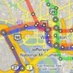
One of our favorite new Tumblrs, Petworthies, noticed that searching for Petworth on Google Maps directs users to a singular address: a “humble example of the Wardman-style row home” located at 4161 9th Street NW. This got us to thinking: where, exactly, does Google Maps peg the location of every other neighborhood in the city?
The map below shows what happens when you search for “[Neighbohood Name], Washington DC” in Google Maps. (We tried to be pretty inclusive here — for a base, we used this list. If your neighborhood isn’t included, let us know and we’ll add it.) Some hoods are self-explanatory (Dupont Circle is centered in Dupont Circle, Navy Yard at the Navy Yard), others are understandable but less-than-exciting (Ivy City’s centered in a parking lot on the campus of Galludet University); some are incredibly representative (West End is represented by a big parking garage/office building) and others are just plain weird (tiny Woodland-Normanstone Terrace is represented by a big tree). Then there are the pleasant surprises, like Washington Highlands’ pin, an overlook onto a sweeping valley from Atlantic Street SE. One thing you will notice? A lack of an entry for Capitol Hill, which, for some reason, didn’t register like every single other neighborhood when we searched for it. Who knows, maybe Google’s got something against Congress.
Without further ado, and for your clicking pleasure:
View Neighborhoods in a larger map