 Image via
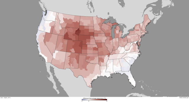
Summer 2012 was the third hottest for the lower 48 states in the 117 years since authorities began keeping track of the weather, according to an in-house publication at the National Oceanic and Atmospheric Administration.
Between June 1 and August 31, the average temperature in the contiguous 48 states was 74 degrees, a mark that trails only the summers of 1936 and 2011, according to NOAA’s ClimateWatch Magazine. Across much of the country, this summer has been marked by oppressive heat, stifling humidity and a devastating drought:
Drier-than-average conditions prevailed across much of the central United States, from the Rocky Mountains to the Ohio Valley. Nebraska’s summer precipitation was almost 6 inches below average, and Wyoming’s precipitation was more than 2 inches below average, marking the driest summer on record for both states. Missouri, Illinois, Iowa, South Dakota, Nebraska, and New Mexico had summer precipitation totals among their ten driest.
The Northeast, Southeast and West Coast got plenty of rain, but the remainder of the country—the D.C. area included—recorded rainfalls far below average.
In Washington, the dog days of summer were especially hairy. Local temperatures exceeded 90 degrees 50 times between June and August; 28 of those instances topped 95 degrees. The end of June was marked by a wicked derecho storm that left hundreds of thousands of area residents without power for up to a week that featured some of the hottest days of the year.
Moreover, the Capital Weather Gang reports that the 12-month period from September 1, 2011 to August 31 was the fourth-hottest on record, while the five hottest 12-month periods have all concluded in 2012.