Rachel Kurzius
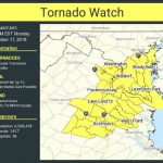
Update, 3:15 p.m.: The National Weather Service just issued a tornado watch for parts of D.C., as well as surrounding areas, through midnight on Halloween.
Across a vast region that goes as far as Pennsylvania and West Virginia, a few tornadoes are “likely” and hail up to the size of a small marble is “possible,” NWS says.
https://twitter.com/NWStornado/status/1189979372897259520
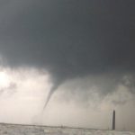
Original: Be careful out there tonight, folks. Forecasters with the National Weather Service warn that a line of thunderstorms coming to the Washington area on the evening of Halloween will possibly be accompanied by damaging wind gusts and the potential for an isolated tornado.
“All the ingredients remain in place for a potentially dangerous severe weather event tonight,” the local NWS office writes. The office forecasts that thunderstorms will likely move east across the region, beginning mid-afternoon in the Potomac Highlands, reaching Washington D.C. and Baltimore later in the evening, and then hitting areas east of I-95 between 9 p.m. and midnight. NWS expects that the storms will last an hour or less.
The chance of precipitation in D.C. is 100 percent, per NWS, with the potential for between 1-2 inches of rainfall and wind gusts as high as 43 miles per hour. Additionally, Capital Weather Gang anticipates that NWS will issue a tornado watch later in the afternoon.
For those planning on trick-or-treating tonight, this forecast means that you ought to have a plan to find shelter quickly.
https://twitter.com/NWS_BaltWash/status/1189939450123444225