 Jordan Pascale
Even when there’s no formal path, people often take the most efficient route when walking from A to B. Over time, trodden grass turns to dirt paths and gets etched into the landscape.
The paths, known as “desire lines” or “goat paths,” often cut through circuitous routes or fill in gaps where sidewalks aren’t built. They connect neighborhoods to schools, businesses, and transit. Often these paths are a result of a car-centric development that created long stretches unsuitable for walking. Such development is a function of how Montgomery County was built.
But now the county’s planning department is documenting those informal paths in hopes of making them safer in years to come.
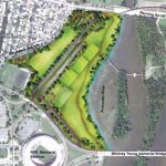
The department has created an online “pedestrian shortcut” map where residents can submit “desire lines” in their neighborhoods.
Residents have entered 150 paths totaling 13 miles since the map went online last week, says transportation planner Eli Glazier.
“These informal connections really exist all over Montgomery County,” Glazier said. “We have connections in downtown Silver Spring, which has really a pretty good built out street grid already.
“But then we also have a ton (in areas) with more suburban development patterns. So there’s a lot of cul-de-sacs where some of these shortcut connections actually can save a ton of time over that traditional sidewalk network.”
The map is part of the county’s first Pedestrian Master Plan, which followed a Bicycling Master Plan a few years ago.
Here are a few examples of what people wrote on the map:
“We use this path to walk to the bus stop on Thayer Avenue or to walk to downtown Silver Spring,” one user wrote. “[It’s] very steep, completely unlit at night and overgrown with Japanese knotweed. People throw their trash here. We avoid it completely when it’s dark or when it rains or snows because it can be really slippery.”
In the North Kensington neighborhood, one person wrote: “This a critical link for students walking to school.”
In Gaithersburg: “A sidewalk connection is desperately needed along Redland Rd. … Adding this 200-yard segment would connect the current sidewalks along Redland Road and allow safer access to the Shady Grove Metro one mile away. Currently, pedestrians and bicyclists are forced to either use the narrow two-lane road portion of Redland Rd or walk along the shoulder, both options very dangerous.”
The Action Committee for Transit, a pedestrian and transit advocacy group in the county, has been pointing out these types of deficiencies on Twitter for years.
Glazier says Montgomery County might not be able to turn every desire line into a sidewalk because of costs and logistics with private land, but the goal is to make many of these paths accessible for everyone.
“These connections are not accessible to people who use wheelchairs or scooters,” Glazier said. “So it’s created this two-tier system where if you use a mobility device, you have to take this circuitous route and where people who feel comfortable can walk can walk on the grass or in the dirt and save a ton of time.
“So part of it is an equity issue in terms of mobility.”
There are also safety issues: Most of these paths aren’t well lit. They can become treacherous after it rains.
“It’s not a reliable, consistent transportation experience,” Glazier said. “So that’s some of the stuff we want to change.”
The map will be open for submissions through the summer and later, the planning department will cull them and prioritize which areas should be included in the master plan. The Montgomery County Department of Transportation would be in charge of implementing the sidewalks on public property, but with a limited budget, the sidewalk projects would be competing against other projects.
This story originally appeared on WAMU.