 Daniella Cheslow
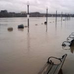
Washington, D.C., Northern Virginia, and parts of Maryland are at risk of flooding Friday afternoon, according to the National Weather Service.
In an advisory, the NWS said scattered slow-moving showers and thunderstorms in the forecast posed a risk of flash flooding. The watch is in effect from noon until late Friday.
The watch comes days after Tropical Storm Isaias bore down on the region, leading to flash flooding in Alexandria and on D.C. roadways. Although Friday’s weather is not expected to be as severe, it could be a good time to refresh with the District’s tips for storm preparations amid a pandemic.
In addition to D.C., the flash flood watch applies to a large part of the region, including Anne Arundel, Calvert, Carroll, Central and Southeast Howard, Central and Southeast Montgomery, Charles, Frederick, Northern Baltimore, Northwest Harford, Northwest Howard, Northwest Montgomery, Prince Georges, Southeast Harford, Southern Baltimore, and St. Marys in Maryland.
In Virginia, the watch includes Albemarle, Arlington/Falls Church/Alexandria, Augusta, Central Virginia Blue Ridge, Culpeper, Eastern Loudoun, Fairfax, Greene, King George, Madison, Nelson, Northern Fauquier, Northern Virginia Blue Ridge, Orange, Page, Prince William, Rappahannock, Rockingham, Southern Fauquier, Spotsylvania, Stafford, and Western Loudoun.