Jacob Fenston
On a hot, muggy day in D.C., nothing could be better than a good swimming hole — a deep spot in a cool, clear-running creek.
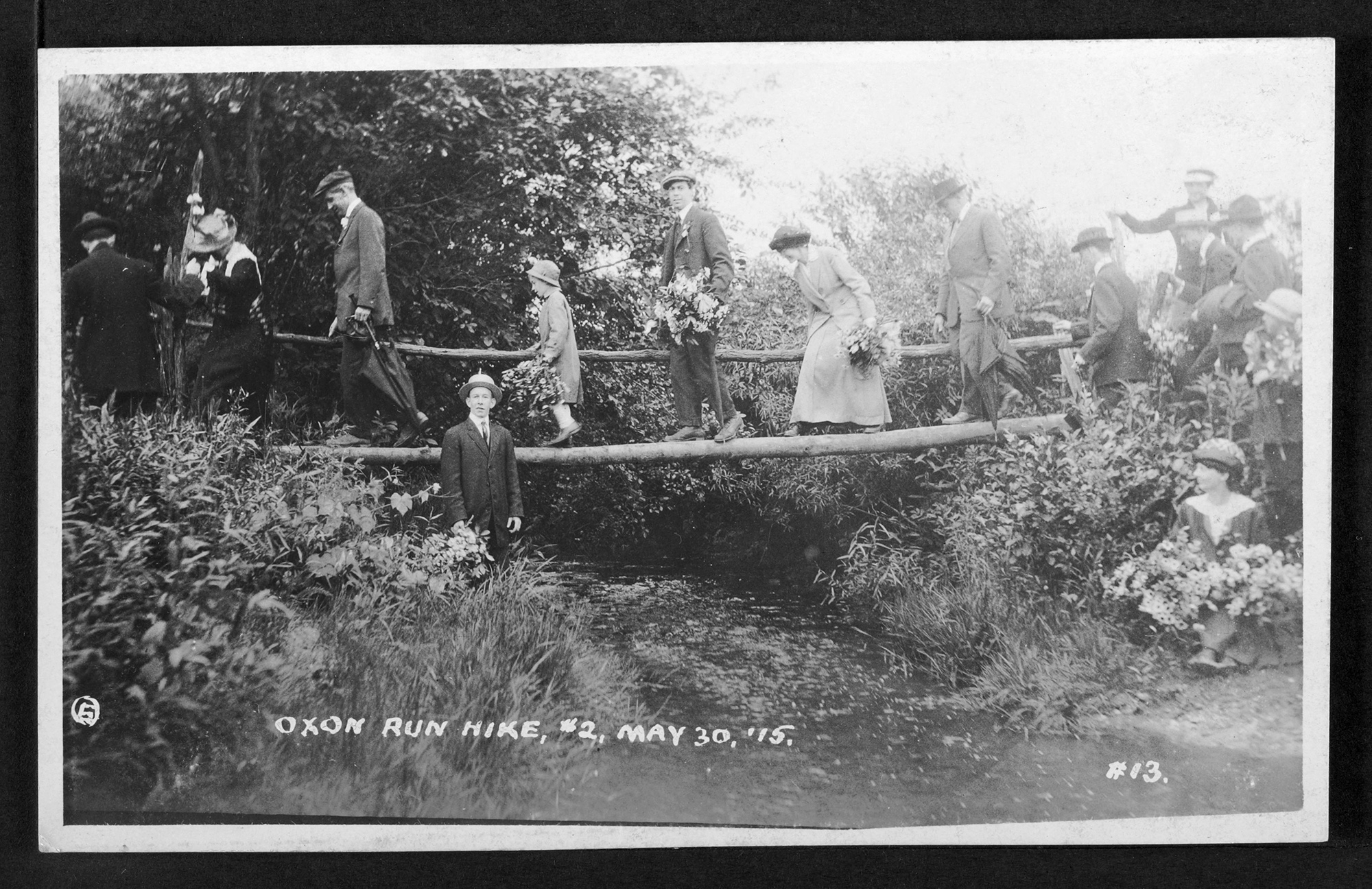
That’s what I set out to find recently, near one of the busiest intersections in Washington: North Capitol St. and New York Ave. These days, it’s a dry landscape of concrete and asphalt. But 150 years ago, it was a popular spot for kids to cool off. In fact, the area around what’s now Union Station was once dotted with swimming holes that carried evocative names like “the Piggory” and “the Blue Cork.”
Washington D.C is a river city, built at the confluence of the Potomac and Anacostia. Once upon a time, it was also a stream city, laced with a vast network of tributaries. Roughly 70% of those historic streams disappeared as the city developed, according to a new District-funded project to document and map the D.C.’s forgotten waterways. The project also analyzed possible locations to bring some streams back aboveground in the future.

Joe Arrowsmith, an ecological engineer with the consultant group Straughan Environmental, led the project with help from David Ramos, who also teaches graphic design at American University (American University holds the license to WAMU, which owns DCist). The D.C. Department of Energy and Environment also collaborated on it.
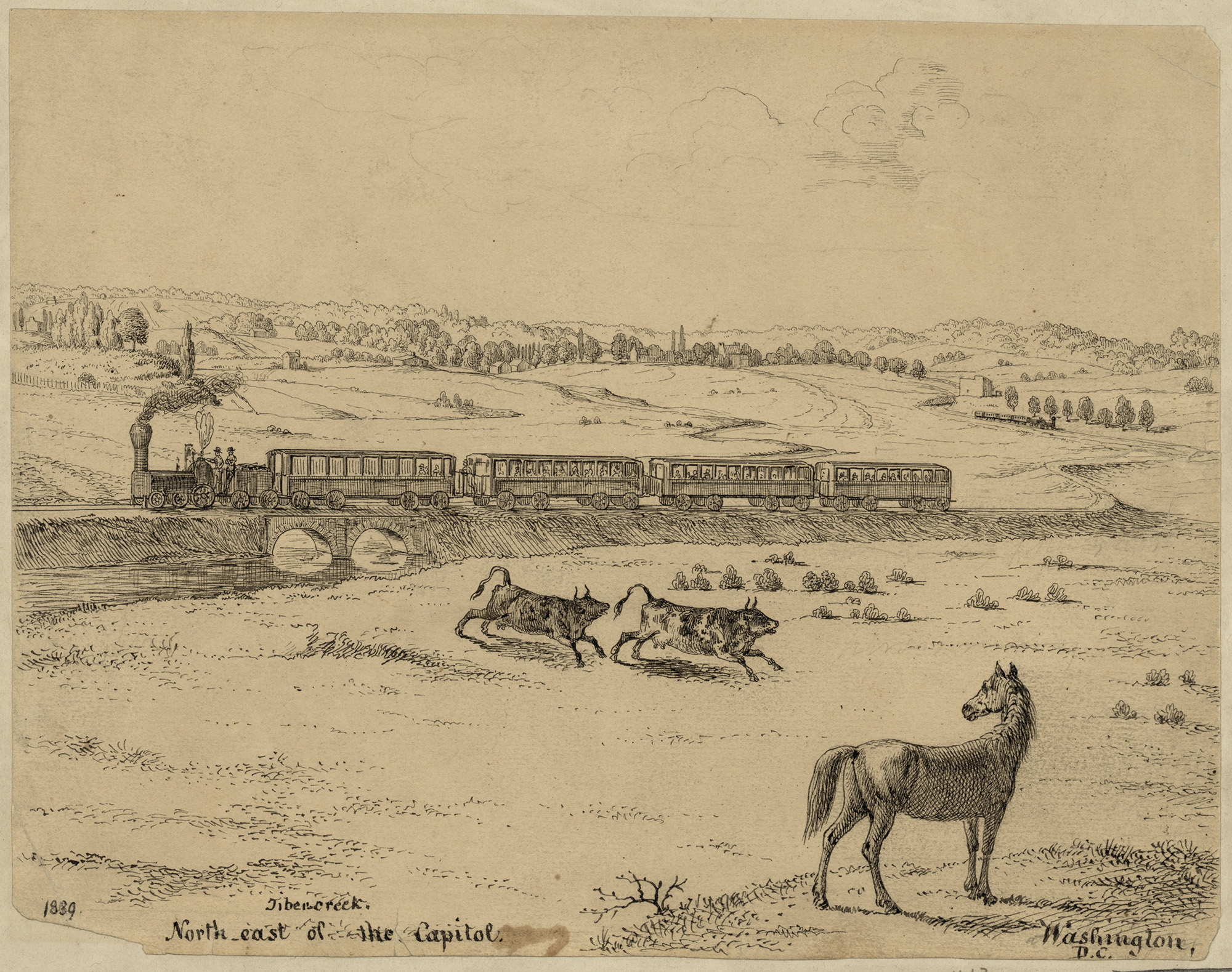
Arrowsmith and Ramos took me on a bike tour of what was once a major waterway: Tiber Creek. It was D.C.’s second-largest creek, after Rock Creek. It flowed through the heart of the city and its watershed covered about one-third of the District. It was also popular for fishing, teeming with shad, herring, eels, pike, catfish, and perch.
But you won’t find the Tiber on any modern map. So where did the Tiber go?
“You see all these manholes on the ground?” Arrowsmith says as trucks rumble past on New York Ave. He explains that when the District’s first sewer system was installed in the late 1800s, the Tiber was put in a huge pipe. That got the creek out of the way as the growing city’s street grid was laid out, and the creek’s waters were harnessed to help wash sewage downstream, away from houses and offices — a big win for public health.
The Tiber, recalled by one resident in the 1870s as a “clear and beautiful stream,” is still here. It’s just underground and mixed with sewage.
D.C.’s streams disappeared through a number of means as the city developed during the 19th and 20th centuries: some streams, like the Tiber, were put to work flushing sewage through pipes; other, smaller creeks were simply filled in and paved over; others dried up “because we paved over the source of water that was infiltrating to feed them,” Arrowsmith says.
‘A Little Bit Tragic’
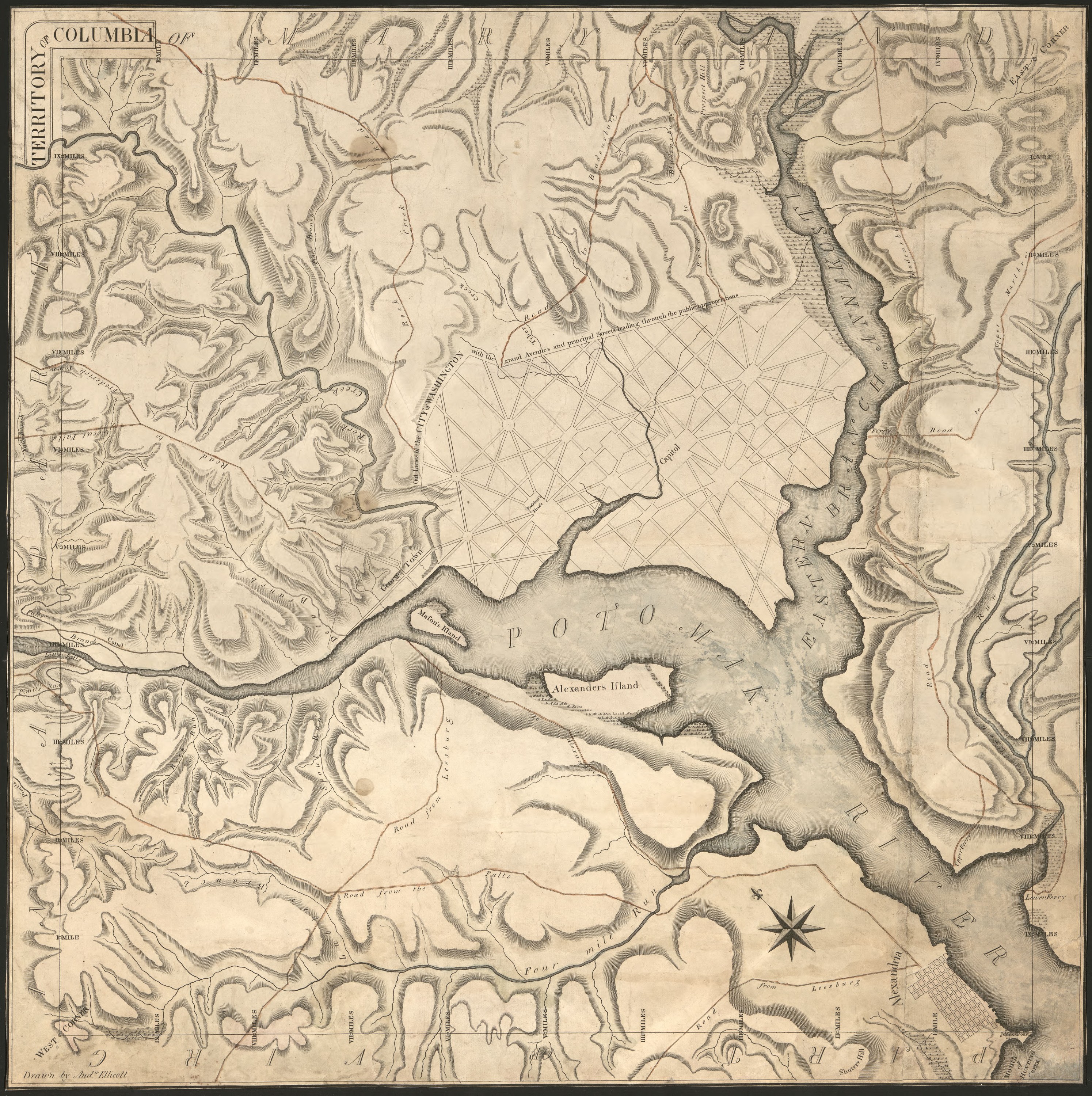
The story of the lower Tiber is one of grand engineering ambitions gone awry. When Pierre L’Enfant drew up plans for a new capital city in 1791, modeled after European centers of power, he envisioned the creek as a stately canal flowing past “Congress House” and “the President’s House.” L’Enfant’s plans showed the stream entering the city at what is now Florida Ave. and New Jersey Ave., then disappearing under the street grid, only to reappear as a canal along what’s now the National Mall, connecting the Potomac and Anacostia Rivers.
What was previously known as Goose Creek, in honor of the waterfowl that flocked to it, was renamed Tiber Creek after the channelized river that flows through Rome. Around the same time, what had been called Jenkins Hill was rechristened Capitol Hill, also after a Roman landmark.
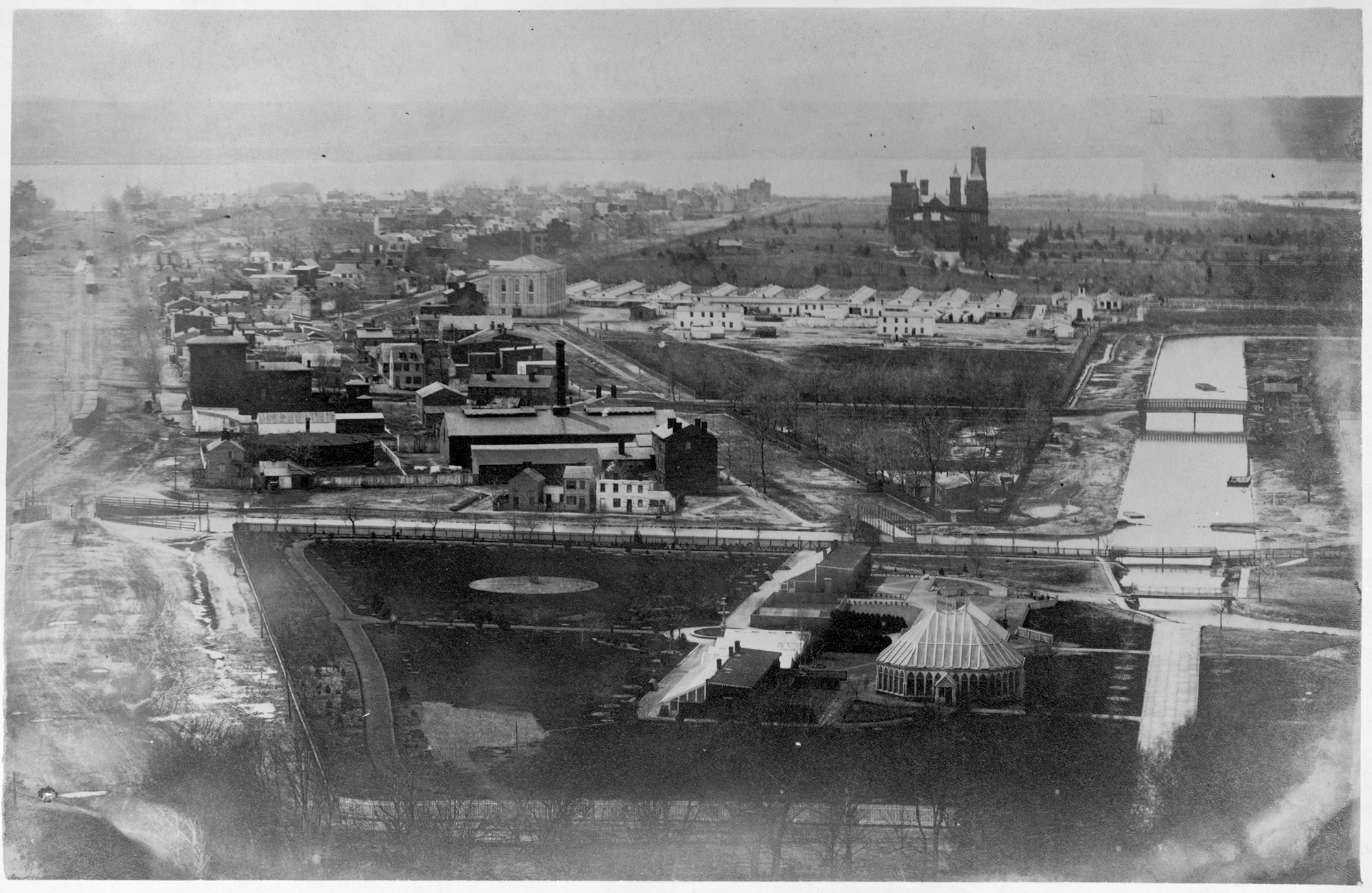
The canal was eventually built following L’Enfant’s plans, but quickly clogged with sediment and sewage. A 1902 Washington Times article referred to the canal as a “foul stream of death,” and complained that “the atmosphere throughout its length and for blocks on either side is poisoned by fumes arising from decomposing filth.”
When the Tiber was harnessed to rush sewage away from population centers in the late 1800s, there was no sewage treatment plant. Instead, the Tiber conveyed the mixture of creek water and feces into the Anacostia River and Potomac River.
“Tiber Creek’s gone from being a free flowing stream to a canal, a misbegotten canal, and then a sewer,” Ramos says. “I find it a little bit tragic.”
Some of D.C.’s creeks did survive development — but only portions remain intact, and they are fed not by freshly filtered groundwater and burbling springs as they once were, but by raw sewage and stormwater runoff from streets and roofs.
For example, old maps show Piney Branch, fed by a network of tributaries, running from the Maryland border near what’s now the Takoma Park Metro Station to Rock Creek in Mount Pleasant — a distance of more than three miles. Now, Piney Branch only exists for about half a mile between 16th St. NW and Rock Creek. Gone are tributaries, replaced by two large floodgates near 16th St. that open into the combined sewer system, which overflows into Piney Branch during rain storms.
The Water’s Landscape Remains
On our bike tour of the Tiber, we headed upstream, looking for the creek’s headwaters.
We pulled off onto the sidewalk near Howard University, where Arrowsmith pointed out the gently rolling hills, now packed with rowhouses. Those hills hint at the city’s watery past.

“If we crested that hill, there would have been another stream on the other side. Likewise behind us, down the hill in this direction, there’d be another one at the bottom of that valley here.”
Now, the streams are all gone, but the topography the streams created remains.
Ramos says it was near here that he first took an interest in the District’s lost waterways. When he would bike across Sherman Ave., he wondered about the downhill and uphill, the distinct valley between 14th St. and Georgia Ave. After looking at old maps, Ramos discovered “it’s one of the tributaries of Tiber flowing down that v-shaped valley.”
“I like that explanatory power,” Ramos says.
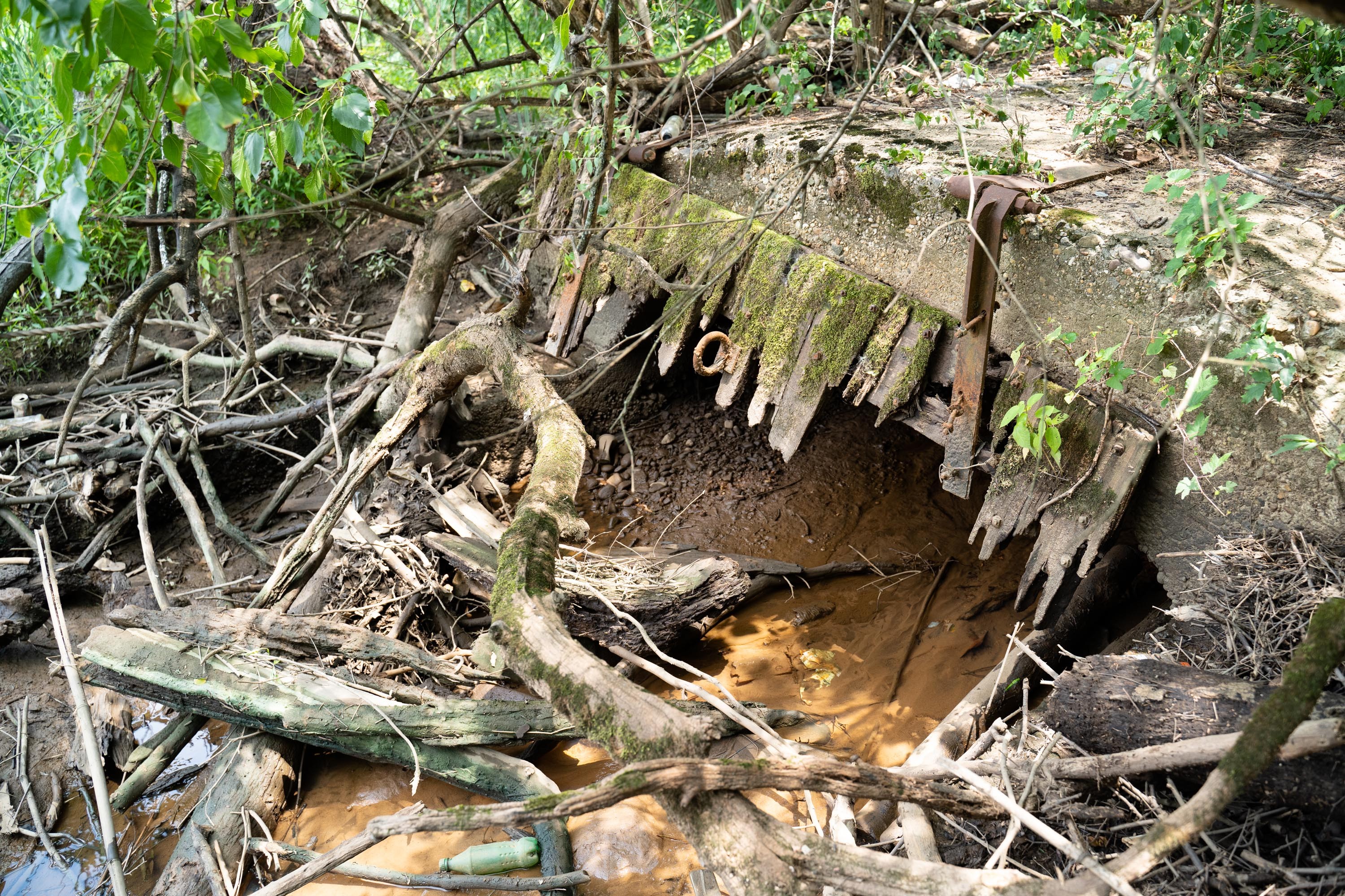
Our next stop was the sprawling grounds of the Old Soldiers’ Home. There’s a golf course, surrounded by a fence. Just beyond the fence we can see a little bridge over what looks like a drainage ditch.
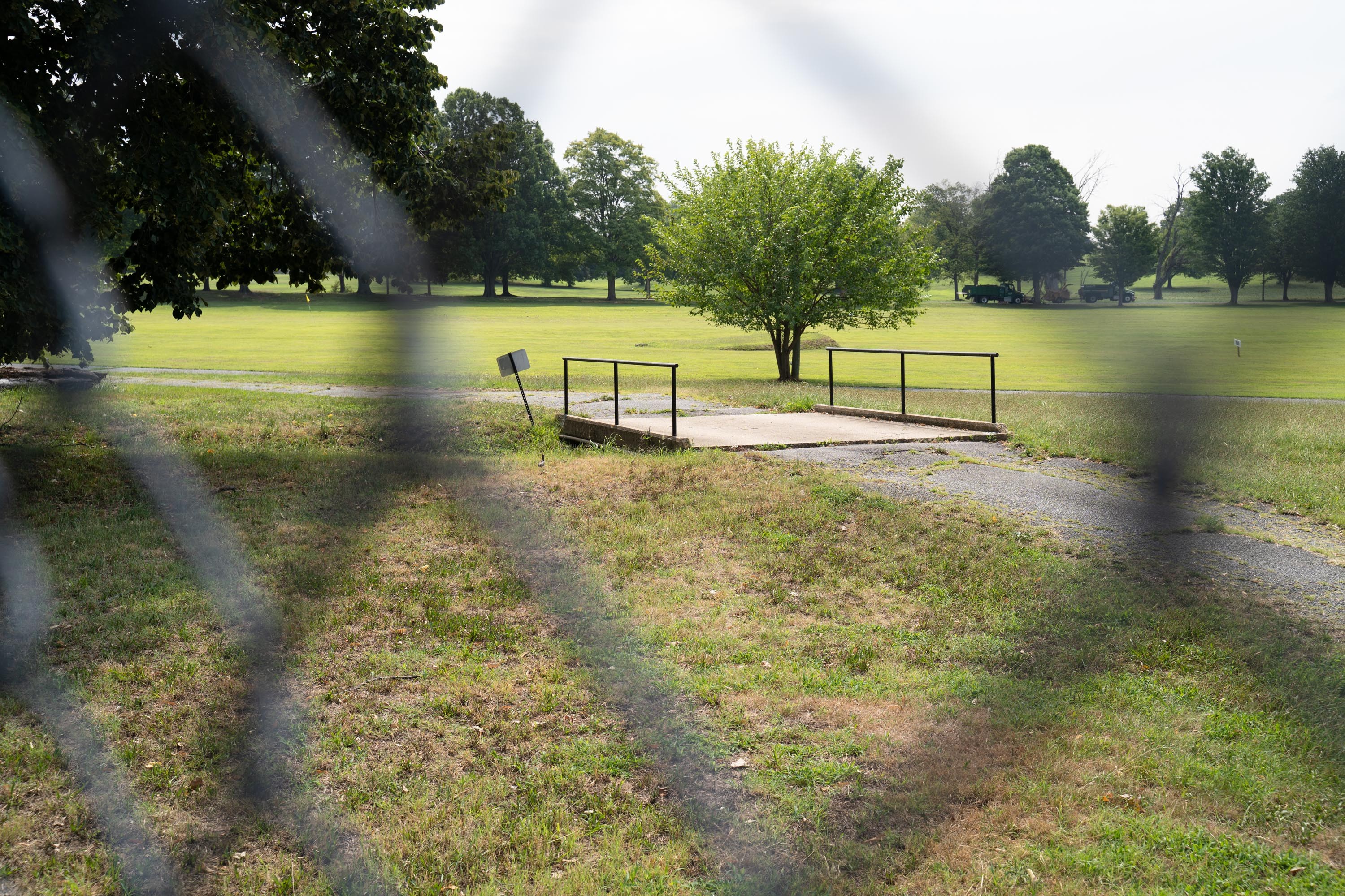
“That ditch is the stretch of Tiber Creek that still survives — the longest stretch of Tiber Creek that’s flowing on the surface today,” Ramos says. “It’s the very headwaters.”
If you squint hard enough through that fence, and ignore the grumble of buses in low gear climbing Rock Creek Church Rd., you can almost imagine you’re looking over a pastoral landscape and not a golf course.
Creeks Could Once Again See Daylight
One of the purposes of the stream mapping project is to better understand where water used to be and how that could relate to current flooding problems. The project’s interactive maps let users zoom in on any neighborhood. You can see where old streams were in relation to where you live, with historic waterways overlaid on top of modern satellite imagery.
The project also identifies where streams could be “daylighted,” or brought back to the surface. The team analyzed more than 500 locations where stormwater discharges into creeks in the city, trying to better understand how today’s stormwater drainage system relates to D.C.’s historic creeks. They picked 100 creeks that could be possible candidates for daylighting, and visited each one.
In those site visits, they found that while many streams probably still need to be in pipes to prevent flooding homes, many others could safely flow on the surface — particularly in parks. From the 100 potential sites, the team narrowed it down to four, and completed some initial designs. Those sites are at the Old Soldiers’ Home, Langston Golf Course, Glover Archbold Park, and Anacostia Park.
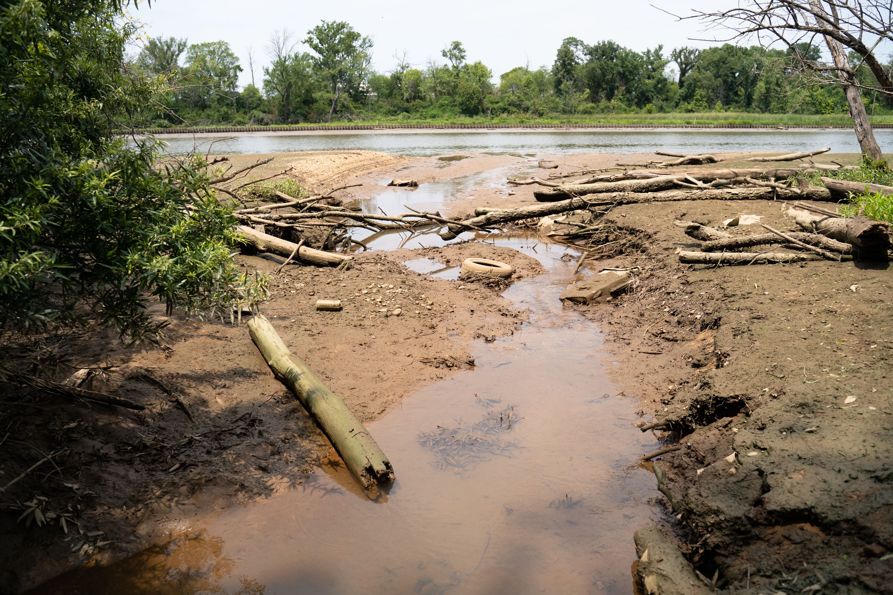
Josh Burch, who works for DOEE on stream restoration projects, led me through an overgrown section of Anacostia Park to visit one potential site where a stream could be daylighted.
“There’s some trees in here, but 90% to 95% of the vegetation is all invasive plant species,” Burch said as we bushwhacked through a landscape overtaken by vines.
Beneath our feet, Fort Dupont Creek runs though an 8-ft.-wide pipe. We arrived at the muddy banks of the Anacostia River, and the mouth of the concrete pipe. The plan is to daylight 450 ft. of the stream, and brink back five to seven acres of wetlands, returning the landscape to what it would have looked like 200 years ago.
“Not only are we going to help clean up the water, but we’re going to be able to bring back the native vegetation that should be along our stream and wetland corridors, which is going to be good for fish, good for aquatic and terrestrial species, but then also for, you know, everyday humans,” Burch says.
It’s no surprise many D.C. residents don’t feel a connection to the waterways in the city — nearly three-quarters of the historic streams disappeared as the city developed. Those that are left are polluted with sewage and stormwater. Daylighting creeks provides a chance to reconnect with the water.
Daylighting can also play a big role in improving the health of downstream waterways — the Anacostia River, the Potomac River, and the Chesapeake Bay.
Daylighting and other stream restoration projects mimic nature — allowing water to flow slowly and expand into floodplains during a storm, rather than rushing water out of the city as quickly as possible. This allows water to infiltrate into the ground, a process that filters out pollutants, and prevents erosion that muddies the rivers. It’s reversing, bit by bit, the process initiated in the 1700s when forests were cut down and streams were paved over.
The project to map D.C.’s lost streams builds on a report put out in 1977 by the U.S. Geological Survey. That paper found that the District’s loss of surface waters was “a necessary consequence of building a city.” But the author also noted the need to protect the waterways we still have, writing: “Cities, to be enjoyable and inspiring places in which to live, need more than asphalt, steel, and glass.”