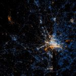
 Photo by Eric Fischer.
Eric Fischer, the man who brought us the fascinating map showing the racial divides of the District, has made a geotagged map of the most photographed parts of the city. He’s done the same in many cities, so check out the set.
Beyond just showing where the photographs are being taken, he denotes who took the photo: tourist or local. Using Flickr and Picasa, Fischer uses blue to denote local photographers, red to denote tourists, and yellow to denote unknown.
Fischer determined the colors by assuming the people who have taken pictures in the city over a range of a month or more as locals. People who appear to be a local of a different city and who took pictures in this city for less than a month are marked as tourists.
It’s a pretty fascinating study of photography in the District, though not necessarily surprising. It’s red near the Mall and the Capitol, blue most elsewhere. It is interesting that east of the Anacostia River is pretty much blank: no one seems to be posting photos online from there.